
All Images
News Release 16-152
Underwater volcano's fiery eruption captured in detail by seafloor observatory
Results offer insights into volcanic eruptions on land, which pose greatest threat to people
This material is available primarily for archival purposes. Telephone numbers or other contact information may be out of date; please see current contact information at media contacts.
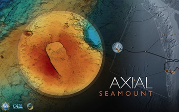
Axial Seamount, located on the Juan de Fuca Ridge in the Northeast Pacific Ocean, erupted in 2015.
Credit: UW Center for Environmental Visualization
Download the high-resolution JPG version of the image. (734.8 KB)
Use your mouse to right-click (Mac users may need to Ctrl-click) the link above and choose the option that will save the file or target to your computer.
Watch a video showing Axial Seamount in the Pacific Ocean, via the Ocean Observatories Initiative.
Credit: NSF/OOI
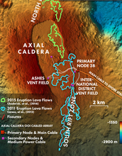
Map of Axial Seamount showing lava flows in 2015 in green and a previous eruption in 2011 in blue.
Credit: John Delaney/UW Center for Environmental Visualization
Download the high-resolution JPG version of the image. (7.7 MB)
Use your mouse to right-click (Mac users may need to Ctrl-click) the link above and choose the option that will save the file or target to your computer.
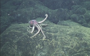
A deep-sea octopus explores brand-new lava that flowed in Axial Seamount's 2015 eruption.
Credit: Bill Chadwick/OSU, and ROV Jason/Woods Hole Oceanographic Institution
Download the high-resolution PNG version of the image. (2.4 MB)
Use your mouse to right-click (Mac users may need to Ctrl-click) the link above and choose the option that will save the file or target to your computer.
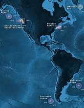
OOI's arrays are deployed in key locations in the Atlantic and Pacific Oceans.
Credit: NSF/OOI/UW Center for Environmental Visualization
Download the high-resolution JPG version of the image. (2.1 MB)
Use your mouse to right-click (Mac users may need to Ctrl-click) the link above and choose the option that will save the file or target to your computer.

Map of the north rift zone of Axial, showing depth changes before and after the 2015 eruption.
Credit: Bill Chadwick/OSU
Download the high-resolution PNG version of the image. (724.8 KB)
Use your mouse to right-click (Mac users may need to Ctrl-click) the link above and choose the option that will save the file or target to your computer.