
The Globe Program
PROGRAM GOAL STATEMENT
![]()
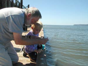
The
Globe Program is a hands-on, science and education program that unites
students, teachers, and scientists from around the world in study and
research about the dynamics of the Earth's environment. Over a million
K-12 students have taken part in the program, and there are more than
22,000 Globe-trained teachers. Hundreds of thousands of Globe students
in over 13,000 schools in more than 100 countries are taking environmental
measurements and reporting their data for use by scientists. In the United
States, Globe is a Federal interagency program sponsored by NASA and the
NSF, in partnership with over 140 colleges and universities, state and
local school systems and non-government organizations. Schools in every
state have adopted Globe.
The goals of the Globe Program are:
- to enhance the environmental awareness of individuals worldwide,
- to increase scientific understanding of the Earth, and
- to improve student achievement in science and mathematics.
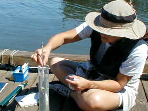
The Globe Program is implemented through a worldwide network of primary and secondary schools where Globe students:
- take environmental measurements at or near their schools,
- report their data through the Internet to the Globe data archive,
- create maps and graphs to analyze Globe data sets, and
- collaborate with scientists and other Globe students around the world.
Globe students have reported data from over 9 million science measurements in the areas of Atmosphere/Climate, Hydrology, Soils and Land Cover/Biology. These global data sets are made freely available via the Internet to the world science community and to the students themselves for scientific research, student-scientist partnerships, and worldwide school-to-school collaborations.
PROGRAM ANNOUNCEMENTS
PROGRAM RELEVANT LINKS
![]()
RELEVANCE TO NATIONAL AND AGENCY MISSION
![]()
Globe supports NSF Geosciences Goals and Objectives:
To benefit the Nation by advancing the scientific understanding of the integrated Earth systems through supporting high quality research, improving geoscience education and strengthening scientific capacity.
- Globe Science investigations are chosen through NSF’s merit-based peer review process for excellence and relevance to key scientific questions.
- Globe provides high quality, peer-reviewed educational geosciences content.
To provide the resulting scientific information in forms useful to society.
- Globe visualizations and data archive are easy to use and form a basis for science and mathematics teaching in thousands of U.S. schools.
- Globe data has been used not only in schoolrooms and in fundamental scientific research, but also in environmental impact statements and even in court cases.
It Supports NSF Education and Human Resources Goals and Objectives:
To help ensure that a high quality school education in science is available to every child in the United States and that it is sufficient to enable those who are interested, to pursue technical careers at all levels, as well as to provide a base for understanding by all citizens.
- Globe demonstrably improves student performance in science.
To help ensure that the educational pipelines that carry all students to careers in science, mathematics, and engineering yield numbers of adequately educated individuals who can meet the needs of the U.S. technical workplace.
- Globe demonstrably improves enthusiasm for science in younger students.
To encourage the development of a cadre of professionally educated and trained teachers to ensure excellence in school education for every student and learner.
- Globe
and its partners provide teacher training in all protocols.
IS THIS AN NSF-WIDE ACTIVITY?
![]()
No, but GEO does collaborate with the Education and Human Resources Directorate within Globe.
IS IT A CROSS-CUTTING ACTIVITY?
![]()
No.
MERIT REVIEW (MAIL & PANEL) STATISTICS
![]()
- Panel Reviews: 8
- Mail Reviews Returned: 20
- Mail Reviews Requested: 23
- Mail Reviews Conflict: 0
- Mail Reviews Declined: 3
- Mail Reviews Late: 0
FY02 (n=10):
REVIEW RATINGS
![]()
No EIS-provided information is available for Globe Review Ratings, but these can be hand-calculated from the raw data.
| REVIEW RATINGS | |||||
|---|---|---|---|---|---|
|
Poor |
Fair |
Good |
Very Good |
Excellent |
Awards |
0 |
0 |
5 |
13 |
8 |
Declines |
1 |
7 |
11 |
12 |
5 |
Other |
0 |
0 |
0 |
0 |
0 |
| MERIT REVIEW DIVERSITY | |
|---|---|
| Male: 52 | White: |
| Female: 15 | Unknown: |
| American Indian or Alaskan: | Handicapped: |
| Black or African American: | |
| Native Hawaiian or Pacific Islander: | New Reviewers: ~20 |
OUTPUTS AND OUTCOMES EXAMPLES
![]()
Grant
Number: 0222375
(Land Cover/Biology - Univ. of New Hampshire)
Nugget: No | High Risk: No | Multi-disciplinary: Yes | Innovative: Yes
The Globe Land Cover/Biology Investigation Team at the University of New Hampshire has been cooperating with teachers and students of Dutchess County, New York for several years. This cooperation has resulted in many students learning much about the use of remotely sensed data for land cover mapping as well as the required protocols for collecting ground sample site information. The team has used advanced image classification techniques to produce a land cover map of Dutchess County, NY from Landsat Thematic Mapper imagery. The classification scheme used to make this map was the Modified UNESCO Classification (MUC) scheme developed by the UNH Land Cover/Biology Team for Globe. Schools within Dutchess County have conducted numerous daylong ground data collection campaigns, called MUC-A-THONS. These ground-collected land cover sample sites provide an excellent source of data for validation or assessment of the accuracy of the land cover map. Accuracy assessment is a critical, yet often overlooked, component of any land cover mapping project. The student-collected MUC-A-THON data were used in conjunction with additional ground data collected by the UNH Land Cover/Biology Team to create a valid reference data set for performing the accuracy assessment. A comparison between the land cover class as labeled on the map and the land cover class as verified on the ground was represented in an error matrix. This matrix provides the descriptive and analytical statistics used in documenting the accuracy of the map. Link to report on Globe website
Grant Number: 9801925 (James Washburne/University of Arizona)
Nugget: No | High Risk: No | Multi-disciplinary: Yes | Innovative: No
This investigation has provided students, teachers, districts and states the opportunity to include a truly meaningful, physical and environmental science component to their curricula. While the Globe program still requires considerable effort to integrate into the school day, more and more programs are moving to incorporate Globe or similar hands-on and integrated Earth Science into their frameworks. This investigation has always faced particular challenges in that soil science is rarely included in most science content. One of the early activities developed and promoted, Just Passing Through, has recently been awarded the task of introducing and tying together Globe's National teacher and trainer workshop agenda. From the simple questions of how fast, how much and what passes through the different soil columns, countless teachers are introduced to Globe. Through the process of prediction, observation and interpretation, these same teachers are introduced to scientific inquiry. Finally, the soil columns and the water passing through are clear evidence of the connections between the hydro and pedo-spheres and connections to the atmosphere and land cover are equally abundant.
This investigation has long championed the idea of effective regional networks of Globe schools working collaboratively with local scientists or environmental interest groups to better collect and motivate the higher-order application of Globe protocols. In particular, they are actively engaged with schools in Arizona and New Mexico and an NSF Science and Technology Center co-located at the University of Arizona (SAHRA, Globe @ SAHRA) to achieve this vision.
Simplicity is a critical issue for these networks and collaborations, since users may have little or no experience running models and may have limited knowledge of soil physics as they relate to heat flow. To facilitate the desired simplicity, the model the project uses is designed as a Microsoft Excel module. The interface is intended to be a familiar style pop-up window with a series simple prompts, easily understood by grade school students. Data is read from any open spreadsheet simply by specifying the column letter. Furthermore, the model is written with open source code so advanced users can easily explore or modify the program, and is based on a soil heat-flux model by Gaylon Campbell. It is driven by air temperature data, collected in this case by HOBO H8 data loggers at 15-minute intervals. Data are read into the model and predicted soil temperatures are printed to columns in an Excel spreadsheet. The program can generate a graphical plot of the observed air temperatures, predicted soil temperatures and observed soil temperatures when available. The user can, if they choose, specify soil water content, clay fraction, upper and lower boundary layer values, bulk density, number of soil layers to be analyzed, depth of soil layers to be analyzed and initial conditions. The user can also opt to accept default values for any or all parameters. The model is calibrated and validated with observed soil temperature collected by Globe participants. A typical one-year data set contains over 30,000 observations at each depth, providing clear seasonal and diurnal cycles. Model output is compared with actual observed data and RMS error is calculated. The model is designed to be implemented across a variety climatic zones and is robust enough to accept incomplete data sets and capable of discerning bad data and parameter values that may be inadvertently entered. Project Website
SIGNIFICANT IMPACTS AND ADVANCES
![]()
Grant
Number:
Nugget: Yes/No | High Risk: Yes/ No | Multi-disciplinary: Yes/No | Innovative: Yes/No
None submitted by program
RESULTS RELEVANT TO THE FIELD, TO NATIONAL PRIORITIES, THE NSF'S MISSION AND TO ITS OUTCOME GOALS (PEOPLE, IDEAS, TOOLS)
![]()
Grant
Number: 9801936
(Paul Ruscher/Florida State University)
Nugget: No | High Risk: No | Multi-disciplinary: Yes | Innovative: Yes
This project's goals involved matching the type of cloud observations taken by Globe teachers and students to those taken by professional meteorologists. This helped to ensure their utilization by more scientists, particularly as Globe provides proportionately more cloud observations to scientists as operational offices move to automated observing systems such as ASOS, which do not record comprehensive cloud observations.
The project scientists also worked on establishing criteria for the acquisition and acceptance of data-logged Globe measurements, which would provide greater time resolution, greater coverage (less missing data), and options for urban schools where weather stations are not secure or locatable due to grounds constraints. This is an important step in the right direction, provided certified or certifiable instruments are used, and calibration is possible. In many schools, automated weather stations are being used for the measurement of temperature, relative humidity, pressure, precipitation, and wind, for example. However, the typical installation, perhaps conducted with a business or broadcast partner, lacks the necessary calibration and assurances that recalibration will be repeated on a regular schedule. By establishing a Globe protocol for data-logged instruments, this project ensured accuracy to a much greater extent.
The project added relative humidity and pressure protocols in support of other, broader, Globe objectives in response to a substantial change in philosophy by Globe program headquarters and all of the atmospheric science PIs in Globe. The projects worked together collaboratively to think about how their own scientific interests could be met with each others' protocols and observations.
Globe will be better able to integrate atmospheric measurements of relative humidity into other Globe protocols (notably, Soils and Hydrology), for the purpose of completing the coverage of the water cycle within a broader scope. This project contributed to comments regarding the evolution of the new Data Logger protocol for soil temperature and atmosphere temperature data being developed by Soil Moisture PI, Jim Washburne (see above example).
Over
62,000 relative humidity observations had been submitted to Globe by the
end of the COV evaluation period, as well as 36,000 pressure observations.
Over 1,000,000 cloud observations had been submitted since the inception
of the modified cloud protocols as well. Project
website
PROGRAM STATISTICS
![]()
Number of Proposal Actions
No EIS-provided information is available for Globe proposal actions, however these can be hand-calculated from the raw data.
| PROPOSAL ACTIONS | |||
|---|---|---|---|
| FY00 | FY01 | FY02 | |
| Awards | 0 | 0 | 10 |
| Declines | 0 | 0 | 0 (12 in FY03) |
| Continuing | 6 | 4 | 0 |
| Closures | 3 | 2 | 4 |
| Other | 0 | 0 | 0 |
Award Size and Duration
- Award Size: $136,882
- Duration: 3.8 years
- Minority involvement: 0
- New Involvement: 6
- Women involvement: 8
FY02 (n=10)
Dwell Time
- Average Dwell Time (months): 5.45 (S. Dev. = 0.41)
- Zero - 6 mos.: 100%
- >6 - 9 mos.: 0%
- >9 - 12 mos.: 0%
- >12 mos.: 0%
FY021: (n=7)
FUNDING RATES & DIVERSITY
![]()
| FUNDING RATES AND DIVERSITY STATISTICS | ||
|---|---|---|
| 2002 | ||
| Overall | Competitive Proposal Actions | 10 |
| Competitive Awards | 10 | |
| Funding Rate | 100% | |
| New Involvement | Competitive Proposal Actions | 6 |
| Competitive Awards | 6 | |
| Funding Rate | 100% | |
| Women Involvement | Competitive Proposal Actions | 8 |
| Competitive Awards | 8 | |
| Funding Rate | 100% | |
- Awards: 0
- Declines: 2 (in FY03)
- Other: 0
EPSCoR States
| Back to COV HOME | Back to OVERVIEW |