
Geosciences Education (Geo-Ed)
PROGRAM GOAL STATEMENT
![]()
Program emphases during the period of interest were as follows:
2000
Track 1: Awards to Facilitate Geoscience Education (AFGE): Proposals could target any educational level: 1) graduate and postdoctoral education and training (outside the framework of normal NSF research grants), 2) undergraduate education, 3) elementary and secondary education, and 4) education outside the classroom. Awards made under this track were intended to facilitate the initiation or piloting of highly innovative educational activities that involved leading geoscience researchers where support was not otherwise available.
Track 2: Application of Digital Libraries to Undergraduate Earth Systems Education: This track supported the establishment of a national digital library which would support and promote high-quality undergraduate education in the geosciences, in particular innovative Earth systems curricula, associated archive data sets, and tools for handling real-time data. In addition to individual focused proposals, larger-scale collaborative proposals were invited that specifically sought to implement the recommendations of the community workshop Portal to the Future: A Digital Library for Earth System Education.
2001
The 2001 Geoscience Education program announcement incorporated only the AFGE track of previous announcements. It did not include a separate digital library track, although where appropriate awardees were strongly encouraged to submit the products of their projects to DLESE.
Proposals could again target the educational levels of the 2000 program, and in appropriate cases, awards could supplement active research grants. A major motivation of the program was to foster collaborations that integrated research and education. Projects that involved active linkages that served this purpose, either then in place or to be developed, were particularly encouraged.
2002
In 2002 the GeoEd program again offered two tracks.
Track 1 considered proposals that integrated geoscience research and education. Awards were intended to facilitate the initiation or piloting of highly innovative educational activities by geoscience researchers and educators when support was not otherwise be available. Awards were intended to provide start-up or proof of concept funding to enable projects to reach a level of maturity to compete for long-term funding from other sources. Awards were expected to complement, but not replicate, awards provided by NSF's Directorate for Education and Human Resources.
Proposals could target the educational levels of the 2000 program, with added attention given to dissemination and evaluation plans. Awardees were strongly encouraged to include the products of their projects in the Digital Library for Earth System Education (DLESE) collection if appropriate.
Track 2 for this competition solicited proposals that supported comprehensive undergraduate faculty professional development and faculty enhancement in the geosciences. Proposals submitted under this track were reviewed in collaboration with the Education and Human Resources Directorate's Division of Undergraduate Education. Awards were to link research universities and institutions with other universities, colleges or research institutions. Activities that were to be supported under this track had to include either faculty preparation for graduate students and postdocs or enhancement of current faculty.
PROGRAM ANNOUNCEMENTS
PROGRAM RELEVANT LINKS
![]()
RELEVANCE TO NATIONAL AND AGENCY MISSION
![]()
The GeoEd program strives to increase the number and quality of faculty and students at various levels who are involved in geosciences education. The GeoEd program contributes to the NSF goal of developing a diverse, internationally competitive, and globally engaged scientific and engineering workforce through the development and sharing of effective educational materials, programs and best practices. The program emphasizes the integration of research and education, and attracts a diverse group of students, teachers, and institutions, providing the foundation for scientific literacy, and potentially geoscience careers.
IS THIS AN NSF-WIDE ACTIVITY?
![]()
No.
IS IT A CROSS-CUTTING ACTIVITY?
![]()
Yes.
MERIT REVIEW STATISTICS (MAIL AD-HOC AND PANEL)
![]()
- Panel Reviews: 127
- Mail Reviews Returned: 0
- Mail Reviews Requested: 0
- Mail Reviews Conflict: 0
- Mail Reviews Declined: 0
- Mail Reviews Late: 0
- Panel Reviews: 267
- Mail Reviews Returned: 3
- Mail Reviews Requested: 3
- Mail Reviews Conflict: 0
- Mail Reviews Declined: 0
- Mail Reviews Late: 0
FY01 (n=43):
FY02 (n=91):
| REVIEW RATINGS | |||||
|---|---|---|---|---|---|
|
Poor |
Fair |
Good |
Very Good |
Excellent |
Awards |
0 |
7 |
13 |
27 |
40 |
Declines |
12 |
57 |
118 |
73 |
35 |
Other |
0 |
1 |
3 |
4 |
3 |
| MERIT REVIEW DIVERSITY | |
|---|---|
| Male: | White: |
| Female: | Unknown: |
| American Indian or Alaskan: | Handicapped: |
| Black or African American: | |
| Native Hawaiian or Pacific Islander: | New Reviewers: |
OUTPUTS AND OUTCOMES EXAMPLES
![]()
Grant
Number: 0224531
(Roberta Johnson/UCAR)
Nugget: No | High Risk: No | Multi-disciplinary: Yes | Innovative: Yes
The Windows to the Universe (W2U) (http://www.windows.ucar.edu) project was initiated in 1995, to develop a user-friendly learning system for students and the general public for the Earth and space sciences, linking to interdisciplinary humanities connections. All content on the W2U site is now available only in English. A project to translate the site into Spanish began in the first quarter of FY03, based on the FY02 action. At present, the site serves over 4 million users per year, ~65% of whom are K-12 students who visit the site frequently for classroom research and free-time browsing. The site is composed of thousands of multi-level hybrid cgi-html pages that are dynamically interpreted to serve content back to the user at the upper elementary, middle, or high school level. Translation of the site into Spanish therefore requires a combination of text translation as well as graphics revision to develop a full second version of the site to serve the Spanish- speaking community.
Grant Number: 0202181 (Ross/Paleontological Research Institute)
Nugget: No | High Risk: No | Multi-disciplinary: Yes | Innovative: Yes
This grant is a good example of a SGER GeoEd grant for a small scale student-scientist partnership project. The Paleontological Research Institute carried out research on Devonian marine invertebrate evolution and ecological dynamics within the northern Appalachian Basin, engaging upper elementary and secondary school students in authentic research. The grant contained an evaluation element to monitor the scientific and educational processes and outcomes.
Approximately 100 classroom based programs in the Syracuse and Utica City School Districts used Devonian fossiliferous samples collected within a two-week period by twenty in-service teachers at a professional development workshop.
The data collected was analyzed for statistical accuracy, and a set of tools were developed to handle student-collected data beyond those in this project, allowing the assessment of other geoscience data sets collected by non-specialists. The project was able to document a partnership between scientists and students that satisfies age-appropriate learning goals for both fourth and ninth grade audiences.
Amy Carey, a Geology student at the State University of New York at Geneseo, interned with the Devonian Seas student scientist partnership during summer 2002. This internship introduced Carey to paleontology, and allowed her to explore the interactions between paleontology research and Earth science education within the context of a natural history museum. Carey conducted research on changes in Allanella sp. morphology through time using Devonian Seas samples, assisted with field-based educator workshops, high school student field trips during which project samples were collected, and helped assess the accuracy of student-generated data. Carey's contributions resulted in a co-authored abstract, presented at the 2002 Geological Society of America annual meeting. Carey wrote in her final evaluation:
'Everything I expected to get out of this internship I did, along with a few things I did not expect. I definitely did not expect to be a contributing author on an abstract. I'll be able to use this to my advantage when I apply to graduate school or look for jobs. Working with such friendly people exposed me to the many things one can do with an interest in paleontology, such as a museum curator and exhibits developer, and I was able to learn not only about their job but the lifestyle that went along with the job. If anything, I feel I got back more from this internship than I could have expected. I am more focused on what I would like to do (or not to do) in my future, I met a lot of great people and made a lot of good contacts.'
SIGNIFICANT IMPACTS AND ADVANCES
![]()
Grant
Number:
Nugget: Yes/No | High Risk: Yes/ No | Multi-disciplinary: Yes/No | Innovative: Yes/No
None submitted by program
RESULTS RELEVANT TO THE FIELD, TO NATIONAL PRIORITIES, THE NSF'S MISSION AND TO ITS OUTCOME GOALS (PEOPLE, IDEAS, TOOLS)
![]()
Grant
Number: 0122080
(Chris Brehme/Island Institute)
Nugget: No | High Risk: Yes | Multi-disciplinary: Yes | Innovative: Yes
People, Ideas and Tools: This grant was made to design and test the collaborative use of Geographic Information Systems (GIS) technology with the goal of making regional scientific data and information relevant to a small community. The Island Institute is currently supporting the development of a community-integrated GIS approach in three Maine island communities: Vinalhaven, Islesboro, and Peaks. The goal of this work is to increase local information management capacity and to make quality information accessible to the entire community, including information that can support planning, conservation, education, and governance.
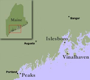
Islesboro and Vinalhaven students used GIS to conduct drift studies in local waters off their respective islands. The drift studies, which were modeled after a pilot project conducted by the Cobscook Bay Resource Center and Shead High School students in Eastport, Maine, involves constructing ocean drifters out of PVC pipe, sand or gravel (for ballast), and bicycle flags (for visibility). Once the drifters are constructed, the students set out in a local lobsterman's boat to track the drifters' movements using GPS units.
Islesboro's AP Environmental Science class performed this study in conjunction with their class work in oceanography. After learning the basics of oceanographic principles in the classroom, students set out to learn more about the movements of the local currents in Gilkey Harbor. With the help of a local lobsterman, the class set out four drifters at high tide and followed their movements for six hours.
Back in the classroom, students downloaded their data and mapped the tracks of the drifters using GIS software. Islesboro Students have completed two drift studies in 2002 and hope to continue each year, with the goal of collecting information on local currents that will be useful to both students and scientists alike.

During the Fall of 2002, Vinalhaven's seventh grade life science class expanded their drift study to relate to larval lobster settlement and class work focusing on the scientific method. Students set out to answer the question "Where around Vinalhaven do larval lobsters settle?" Because lobsters float with the currents throughout their larval stages, local currents affect where juvenile lobsters settle on the seafloor.
The project began with a visit from scientists from The Lobster Conservancy, who explained lobster biology to the students. The students then set about building four drifters. They set the drifters out at high tide in the Reach along the south side of Vinalhaven, and with the help of a local lobsterman, tracked the drifters for three hours.
In the classroom, students used GIS maps of bathymetry and substrate to create a 'best habitat' map. They used this information along with their currents data to write a hypothesis about where they thought larval lobsters would settle. Students tested their hypothesis using juvenile distribution and density data collected by The Lobster Conservancy.
PROGRAM STATISTICS
![]()
Number of Proposal Actions
The Geo-Ed program began making awards in FY01.
- Awards: 16
- Declines: 25
- Withdrawals: 1
- Projects Closed : 2
- Awards: 15
- Declines: 73
- Projects Closed: 2
FY01:
FY02:
Award Size and Duration
- Award Size: $50,581
- Duration: 1.5 years
- Minority involvement: no EIS data
- New Involvement: 7
- Women involvement: 7
- Award Size: $75,788
- Duration: 1.6 years
- Minority involvement: 3
- New Involvement: 16
- Women involvement: 7
FY01 (n=18)
FY02 (n=18)
Dwell Time
- Average Dwell Time (months): 4.44 (S. Dev. = 0.92)
- Zero - 6 mos.: 100%
- >6 - 9 mos.: 0%
- >9 - 12 mos.: 0%
- >12 mos.: 0%
- Average Dwell Time (months): 5.50 (S. Dev. = 0.987)
- Zero - 6 mos.: 60%
- >6 - 9 mos.: 40%
- >9 - 12 mos.: 0%
- >12 mos.: 0%
FY01: (n=43)
FY02: (n=90)
FUNDING RATES & DIVERSITY
![]()
| FUNDING RATES AND DIVERSITY STATISTICS | |||
|---|---|---|---|
| 2002 | 2001 | ||
| Overall | Competitive Proposal Actions | 91 | 43 |
| Competitive Awards | 18 | 18 | |
| Funding Rate | 20% | 42% | |
| Minority Involvement | Competitive Proposal Actions | 12 | 2 |
| Competitive Awards | 3 | 0 | |
| Funding Rate | 25% | 0% | |
| New Involvement | Competitive Proposal Actions | 56 | 21 |
| Competitive Awards | 16 | 7 | |
| Funding Rate | 29% | 33% | |
| Women Involvement | Competitive Proposal Actions | 34 | 17 |
| Competitive Awards | 7 | 7 | |
| Funding Rate | 21% | 41% | |
- Awards: 0
- Declines: 6
- Other: 0
EPSCoR States
| Back to COV HOME | Back to OVERVIEW |