
Impact
Underwater GPS changes the map
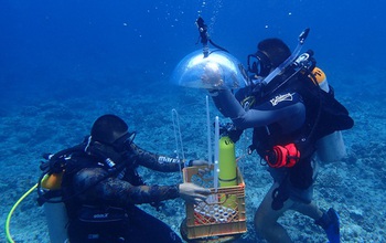
Mapping technique transforms how oceanographers monitor the seafloor
A combination of advanced imaging, GPS buoys and software improves seafloor observation.
Credit and Larger Version
February 1, 2018
This material is available primarily for archival purposes. Telephone numbers or other contact information may be out of date; please see current contact information at media contacts.
In Guam, researchers developed a method for mapping underwater areas that is transforming how oceanographers observe the seafloor. Data from global positioning satellites are the primary method for mapping the Earth, but it's impossible for global positioning system (GPS) signals to pass through water, making detailed mapping of underwater features difficult. By synchronizing underwater cameras with GPS buoys and using software to geo-tag photographs, NSF-funded researchers have mapped all of Guam's Pago Bay and Apra Harbor.
NSF Directorate(s):
Office of Integrative Activities
Locations
Guam
Related Awards
#1457769 Guam Ecosystems Collaboratorium
Related Websites
Guam EPSCoR: http://guamepscor.uog.edu
This NSF Impact is one of thousands of research outcomes made possible by NSF that help fuel the U.S. economy, enhance national security and sustain U.S. global leadership by advancing knowledge. You can search for more NSF Impacts at https://www.nsf.gov/impacts.
Get Impacts by Email