Figure from Export of Weddell Sea water along and over the South Scotia Ridge
Return to the article from which this figure is taken.
|
|
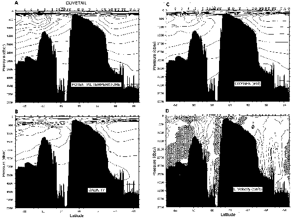
| ( A )Potential temperature, C; ( B ) salinity; ( C ) oxygen, in milliliters per liter; and ( D ) cross-section velocity, in centimeters per second of the DOVETAIL August 1977 ( NBP 97-5) section along 45W. See Muench ( Antarctic Journal , in this issue) for station map. The section extends from the southern Scotia Sea to the northern Weddell Sea. The -0.7C or colder bottom water south of the Orkney Plateau (stations 24 to 32) represents the export of Weddell Sea Bottom Water. Overflow of Weddell water into the Scotia Sea cools the bottom water in the deep trough north of the Orkney Plateau (stations 7-16) to below 0C, colder than water derived from the Drake Passage. The below 0C bottom water over the southern slope of the Orkney Plateau (stations 21-23) represents a well-ventilated layer derived from the Weddell-Scotia Confluence. The warm deep water stratum near 500 meters is weakened over the Orkney Plateau, which also marks the influence of the Weddell-Scotia Confluence. The cold winter surface layer was covered by sea ice south of station 5. |