Figure from Deep coastal oceanography from McMurdo Sound to Marguerite Bay
Return to the article from which this figure is taken.
|
|
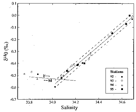
| Figure 2. Oxygen isotope/salinity diagram for stations in Pine Island Bay (74°50'S 102°40'W) in the southeast Amundsen Sea. The solid line fit to the deeper samples extrapolates to a zero-salinity d 18 O content near -29, the probable mean value for precipitation on the Pine Island Glacier (75°10'S 100°00'W) catchment basin. Dashed lines indicate the precision of d 18 O measurements by S. Khatiwala at Lamont-Doherty. |