Figure from Deep coastal oceanography from McMurdo Sound to Marguerite Bay
Return to the article from which this figure is taken.
|
|
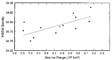
| Figure 1. Average salinity at 450-550-meter depths in the High Salinity Shelf Water (HSSW) on the continental shelf in the western Ross Sea (160°E-180°E) versus sea-ice range the previous year. Each point represents salinity data for one summer, usually December through February, with sea-ice range calculated from the Ross sector preceding winter maximum minus the prior summer minimum. (km 2 denotes square kilometers.) |