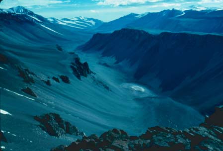
Antarctica is of considerable importance to humanity today. The present section of this report addresses the more significant of these aspects.
In support of its finding that "maintaining an active and influential presence in Antarctica, including year-round operation of South Pole Station, is essential to U.S. interests," the National Science and Technology Council in its April 1996 report on the U.S. Antarctic Program cites the criticality of the U.S. maintaining a decisive role in the maintenance and operation of the Antarctic Treaty. Indeed, it is clear in reviewing the historic record that it is in substantial part due to the proactive leadership role played by the U.S. in the Antarctic that this vital experiment in the governance of a non-sovereign territory has been so successful.
This commitment to an active, permanent presence in Antarctica has long been understood and supported by the U.S. Government:
In response to a request from the Panel, the U.S. Department of State on January 27, 1997, provided a statement which includes the following passage [complete text in Appendix III]:
The basis for U.S. historic policy toward Antarctica (Section 5.2) has in no way been diminished by global events over the intervening years since the Treaty was ratified. To the contrary, it has become increasingly clear to the global scientific and policy-making establishments, as well as to the general public, that the polar regions serve as the global environmental "barometer" with respect to the depletion of ozone in the upper atmosphere, global warming, and the impact of these phenomena on living systems. Antarctic research complements related activities in the rest of the world, including the Arctic.
The U.S. presence and its central role in bolstering the Antarctic Treaty are symbolically and physically manifested in the operation of the Amundsen-Scott South Pole Station. The site lies on the Earth's axis of rotation, the geographic apex of territorial claims. The station, and the U.S. commitment to research there, are a keystone to the maintenance of the Antarctic Treaty as well as a testament to the U.S. commitment to understand the global environment. Intermittent U.S. presence in Antarctica, and particularly at the Pole, would preclude the conduct of much of the research now underway and would undermine the U.S. policy of non-sovereignty.
The Antarctic "barometer" is also relevant to U.S. national security policy and interests since climatic effects are recognized as having a direct connection to the political stability of nations. Increased drought, for example, can, through agricultural impacts, have profound economic and political implications in developing nations. Understanding trends in climate can assist in identifying possible corrective actions and anticipating future global security issues.
United States policy for Antarctica has evolved over a period of years. It is based on four principles: the U.S. recognizes no foreign territorial claims; it reserves the right to participate in any future uses of the region; Antarctica shall be used for peaceful purposes only; and there shall be free access for scientific investigation and other peaceful pursuits.
As early as 1948, drawing on its leadership in Antarctic and world affairs, the U.S. proposed an international trusteeship. Under this plan the seven claimant nations and the U.S. (and other nations, if they wished) would have agreed "not to seek a division of the territory in the area, but to join with the others." The eight nations would make joint explorations and would have free access over the area.
For a decade the idea did not gain necessary support. Then the International Geophysical Year renewed ties among nations involved in Antarctica, and in May 1958 President Dwight D. Eisenhower invited the 11 other Antarctic IGY nations to Washington to draft an Antarctic Treaty. He wrote: "The U.S. is dedicated to the principle that the vast uninhabited wastes of Antarctica shall be used only for peaceful purposes...We propose that Antarctica shall be open to all nations to conduct scientific and other peaceful activities there." Referring to the IGY, the President wrote: "Our proposal is directed at insuring that this same kind of cooperation for the benefit of all mankind shall be perpetuated."
Secretary of State John Foster Dulles referred to the extensive activities of U.S. expeditions to the Antarctic and set forth the basic position and proposal of the U.S. in the following words:
"In view of the activities of the U.S. and its nationals referred to above, my Government reserves all of the rights of the U.S. with respect to the Antarctic region, including the right to assert a territorial claim or claims.
"It is the opinion of my Government, however, that the interests of mankind would best be served, in consonance with the high ideals of the Charter of the United Nations, if the countries which have a direct interest in Antarctica were to join together in the conclusion of a treaty which would have the following peaceful purposes:
1) Freedom of scientific investigation throughout Antarctica by citizens, organizations, and governments of all countries...
2) International agreement to ensure that Antarctica be used for peaceful purposes only.
3) Any other peaceful purposes not inconsistent with the Charter of the United Nations. It is believed that such a treaty can be concluded without requiring any participating nation to renounce whatever basic historic rights it may have in Antarctica, or whatever claims of sovereignty it may have asserted. It could be specifically provided that such basic rights and such claims would remain unaffected while the treaty is in force, and that no new rights would be acquired and no new claims made by any country during the duration of the treaty."
The nations met, the Antarctic Treaty was written, and all the proposed provisions were incorporated into it. The Antarctic Treaty entered into force in 1961 and became the keystone of U.S. Antarctic policy.
In October 1970 President Richard M. Nixon stated U.S. policy for Antarctica to be "to maintain the Antarctic Treaty and ensure that this continent will continue to be used only for peaceful purposes and shall not become an area or object of international discord; to foster cooperative scientific research for the solution of worldwide and regional problems, including environmental monitoring and prediction and assessment of resources; and to protect the Antarctic environment and develop appropriate measures to ensure the equitable and wise use of living and non-living resources." The President added: "Science has provided a successful basis for international accord, and the Antarctic is the only continent where science serves as the principal expression of national policy and interest."
In 1970 and again in 1976 National Security Decision Memoranda (71 and 318) reaffirmed the "importance of maintaining an active and influential U.S. presence in the Antarctic that is 'responsive to U.S. scientific, economic, and political objectives.'"
In February 1982 President Ronald Reagan in White House Memorandum 6646 reaffirmed the prior policy and noted that the presence in Antarctica shall include "the conduct of scientific activities in major disciplines" and "year-round occupation of the South Pole and two coastal stations."
On 9 June 1994 Presidential Decision Directive NSC 26 ( "United States Policy on the Arctic and Antarctic Regions") stated that U.S. policy toward Antarctica has four fundamental objectives: (1) protecting the relatively unspoiled environment of Antarctica and its associated ecosystems, (2) preserving and pursuing unique opportunities for scientific research to understand Antarctica and global physical and environmental systems, (3) maintaining Antarctica as an area of international cooperation reserved exclusively for peaceful purposes, and (4) assuring the conservation and sustainable management of the living resources in the oceans surrounding Antarctica.
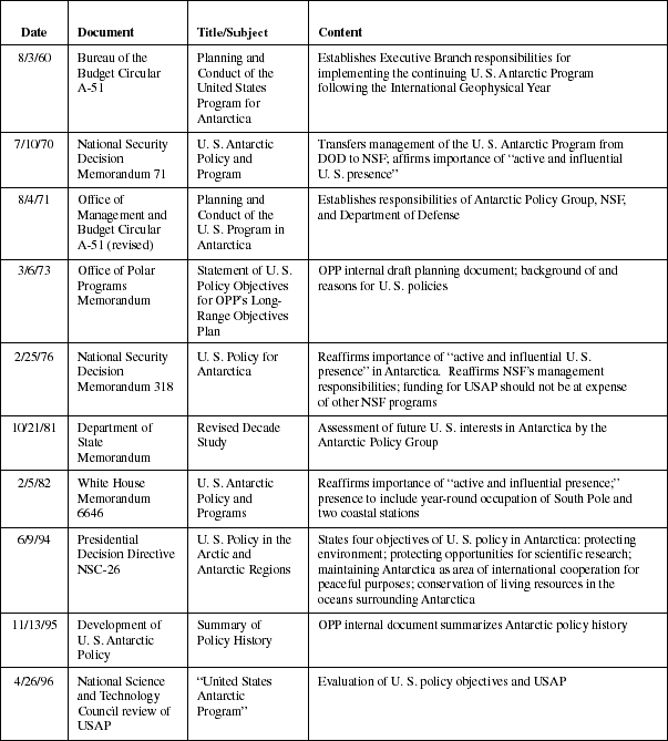
An April 1996 report, U.S. Antarctic Program, by the President's National Science and Technology Council, directed the establishment of the present Panel and reaffirmed that essential elements of U.S. national and scientific interests are well served by continued involvement in scientific activity in the Antarctic as carried out by the U.S. Antarctic Program. The report states that policies in the 1982 memorandum continue to be appropriate at the current funding level and that present U.S. policy and practice with respect to the U.S. Antarctic Program are well justified (Exhibit 36).
Exhibit 36
U.S. Government Executive Branch policy statements regarding Antarctica.
The Antarctic research program comprises the following areas of endeavor: aeronomy and astrophysics, biology and medicine, geology and geophysics, glaciology, and ocean and climate systems. The science benefits from Antarctica's uniqueness as a natural laboratory where certain types of research can best or only be undertaken. The program includes fundamental research designed to provide an understanding of the Earth and its systems, such as the role of the Antarctic in Earth's climate and geological history. Antarctic research addresses specific adaptations of polar organisms; e.g., ice algae and Antarctic fish living in 28°F. The Antarctic also provides a window for study of near-Earth and deep space, including study of the origins of the universe.
"Space weather," driven by solar flares, compresses the Earth's magnetic field and affects electrical power grids and communications around the planet. These phenomena are strongly manifested at the poles, where they are usefully studied. Such interactions may even affect Earth's weather.
The USAP has pioneered the use of Automated Geophysical Observatories that monitor these processes year-round at remote sites on the polar plateau, greatly increasing our understanding of Earth-space interactions, and perhaps leading to improved predictions of space-based disturbance of human-built technical systems.
The polar ozone depletion work being conducted in Antarctica (Exhibits 37 through 40) has been critical in answering questions concerning conditions in the upper atmosphere that exacerbate the loss of ozone. Antarctica also provides the site of the world's cleanest air and as such is a baseline for studies of atmospheric chemistry at ground level.
The Antarctic ozone hole. Monitoring of Antarctic ozone began at the British Antarctic Survey station at Halley Bay, Antarctica, during the International Geophysical Year in 1957. By 1984, observations at Halley Bay revealed ozone values 30 percent below those observed in the previous decades of measurement, and the researchers announced their remarkable discovery of an ozone "hole." Their findings were quickly verified by other measurements, including those from South Pole Station (Exhibit 37).
In 1986 and 1987, USAP undertook the National Ozone Expedition to probe the cause of this remarkable thinning of the ozone layer. USAP's facilities in the Antarctic (particularly the unique ability to operate ski-equipped LC-130 aircraft) allowed a group of researchers to attack the problem quickly and, most importantly, to arrive at McMurdo Station in August. Ozone amounts were close to normal in late August, but dropped rapidly during September. The region of 'missing ozone' was shown to extend from about 7 to 12 miles altitude; near 10 miles most of the ozone was removed (Exhibit 38).
Observations of stratospheric ozone and many of the molecules involved in ozone chemistry (including chlorine monoxide, chlorine dioxide and nitrogen dioxide) were made at McMurdo in 1986 and 1987. These observations pointed towards human activities as the likely cause of the ozone hole. It is now established that the Antarctic ozone hole is caused mainly by perturbed chemistry due to human use of chlorofluorocarbons (CFCs). Ozone depletion is most pronounced in the Antarctic because extremely low stratospheric temperatures lead to polar stratospheric clouds, the particles of which provide surfaces upon which chemical reactions occur to free the chlorine from stable compounds and make it available to destroy ozone in a catalytic cycle. The ozone depletion occurs in the Antarctic spring because the process requires a combination of low temperatures and sunlight. In winter the Antarctic is too dark for much ozone loss, while in summer it is too warm.
International agreements are in place to eliminate global use of chlorofluorocarbons. Because of the long lifetime of CFCs, their impact on the atmosphere will decay slowly, and the Antarctic ozone hole will persist for decades. Exhibit 37 illustrates work at the South Pole Station to monitor the recovery of Antarctic ozone, documenting the atmospheric response to the unprecedented policy decision to phase out the ozone-depleting compounds. Exhibit 37 shows that observations of changes in the the detailed shape of the vertical profile of ozone (particularly in the key 7-12 mile altitude range where most of the ozone loss occurs) should allow the first detection of recovery near the year 2010.
U. S. researchers are studying the biological impact of the ozone hole. Recent studies have shown that phytoplankton that form the base of the food chain in the waters surrounding Antarctica can be affected by changes in ultraviolet radiation due to ozone depletion. Ongoing research is aimed at documenting this sensitivity and its implications for the Antarctic ecosystem. In March 1997 researchers presented the first direct evidence that increased ultraviolet light damages the DNA of animals the eggs and larvae of icefish, an Antarctic fish lacking hemoglobin. The eggs accumulate DNA lesions called cyclobutane pyrimidine dimers.
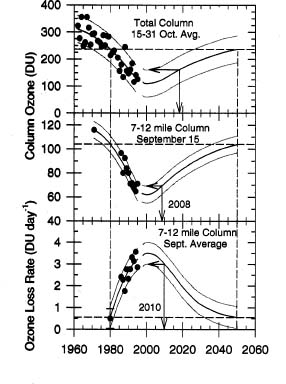
Exhibit 37
The top box shows the amount of total ozone measured from the surface in the air column over the South Pole, in Dobson units (DU), for the last half of October following the austral springtime ozone depletion process. The middle box shows the ozone amount present in the 7 to 12 mile altitude region on September 15, midway through the depletion process, obtained from balloon-borne ozonesonde measurements. The bottom box shows the ozone loss rate (DU per day) in the 7 to 12 mile altitude region during September. Each dot gives the value for one year. The triple curves in each box are average smooth curves with upper and lower bounds for the 1960 to 1995 data (the most recent data used here) and extend into the future to predict recovery based on stratospheric chlorine, which is projected to peak around 2000 and reach the 1980 level around 2050. Unambiguous confirmation that ozone recovery is underway will probably not be possible in the total ozone measurements until about 2018, while the indicators obtained at 7 to 12 miles from the ozonesonde data should allow detection in the 2008-2010 time period.
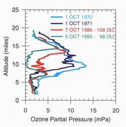
Exhibit 38
Balloon-borne ozone observations at the South Pole in four selected years showing the worsening of the ozone hole over time. The total ozone values for the 1970 and 1971 soundings were about 300 Dobson units (DU). mPa = millipascals. Graphs in exhibits 37 and 38 provided by Dr. David Hofmann, Climate Monitoring and Diagnostics Laboratory, NOAA.
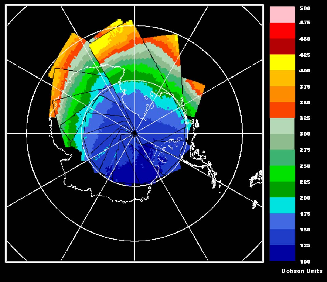
Exhibit 39
Total ozone over Antarctica on October 6, 1996, collected at McMurdo from a satellite as it passed overhead every 95 minutes. University of Wyoming researchers at McMurdo used the real-time images to schedule the release of balloon-borne instruments to collect data on polar stratospheric clouds and ozone. The ozone sensors collect data similar to those in Exhibit 38. Because some balloons carried expensive sensors designed to measure polar stratospheric clouds, which are more common well within the ozone hole, the real-time satellite measurements of the ozone hole formed an integral component in guiding the research. The lowest ozone levels for the year lie in the deep blue area in East Antarctica. Satellite data are from NASA's Total Ozone Mapping Spectrometer (TOMS) on its Earth Probe satellite.
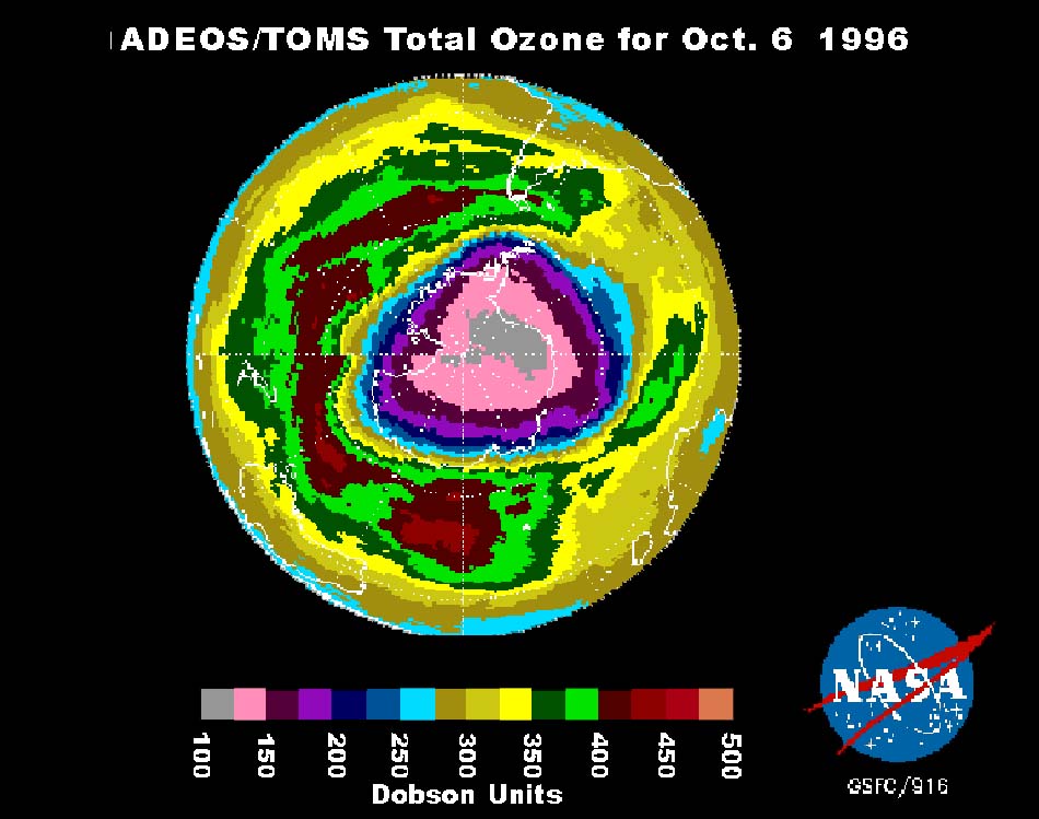
Exhibit 40
Total ozone over the southern hemisphere on October 6, 1996, from a NASA TOMS instrument on the Japanese ADEOS satellite. The lowest values for the year are in the gray areas over East Antarctica.
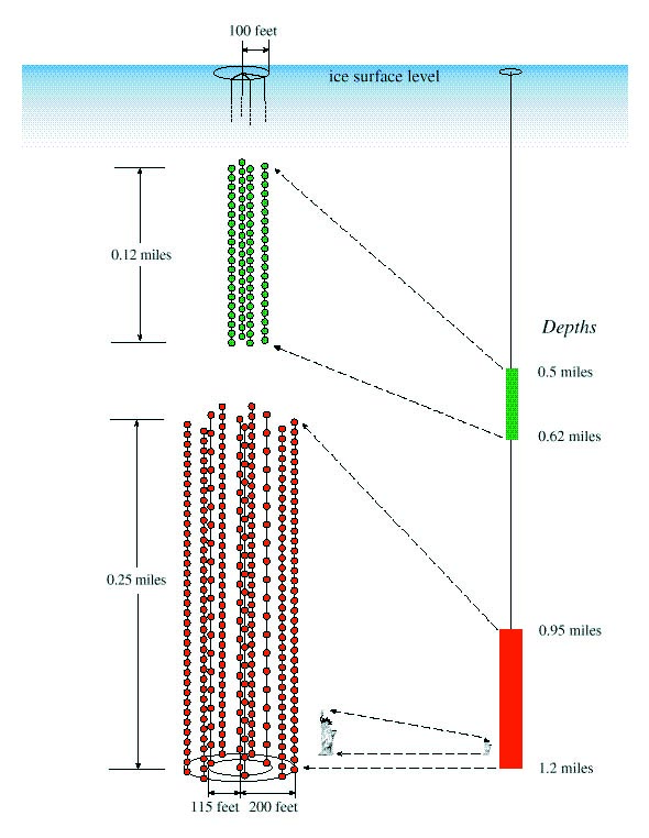
The Antarctic Muon and Neutrino Detector Array (AMANDA) uses the deep ice at the South Pole as the largest neutrino telescope on Earth. The clean air and low atmospheric water-vapor content on the polar plateau make it very likely the best instrumented site on Earth for study-ing the radiation left from the origin of the universe as well as other radiation of similar wavelengths (Exhibit 41).
Exhibit 41
AMANDA (Antarctic Muon and Neutrino Detector Array). There are many ways to study the universe. Our early ancestors used their eyes, Galileo a telescope. Modern astronomers use the infrared and gamma-ray portions of the electromagnetic spectrum, among other portions, to look at the universe, just as physicians use x-rays to see inside living tissue. Recent technology has made possible "telescopes" that image the sky in high-energy neutrinos. Neutrinos are common subatomic particles, but they interact only weakly, and enormous numbers pass through Earth without interacting. They do collide from time to time with nuclei of water molecules, whether liquid or frozen, and detectors are being built in the Mediterranean, Lake Baikal in Russia, and the Antarctic ice sheet.
AMANDA at the South Pole exploits the advantages of ice over water as a detector. Photo detectors are lowered into holes in the ice made using hot water, then they freeze in place. The detectors look downward, so the entire Earth shields them from interactions caused by particles other than neutrinos. The diagram, provided by Dr. Robert Morse, University of Wisconsin, shows the array of 14 strings as it was in early February 1997. Each ball is a glass sphere about 16 inches in diameter inside of which is a photomultiplier tube that registers the neutrino interactions. Ice is more effective than water because it has no radioactivity or bioluminescence; the low temperature also reduces detector noise. The wires run just to the surface, rather than long distances to shore. A disadvantage of ice is that the detectors are permanently frozen in place and can't be changed when they malfunction. Also, the ice sheet at the South Pole (9,300 ft.) is not as thick as the Mediterranean is deep, so the non-neutrino background at South Pole is higher.
Conditions in the summer months in Antarctica, ice covered, continuously sun-lit, and surrounded by ocean, are also ideal to undertake Long-Duration Ballooning for scientific data gathering. Stratospheric circulation in Antarctica allows long-term experiments not otherwise possible on Earth, because the balloons literally circumnavigate the continent. The balloons carry payloads on a routine basis weighing a ton or more. In many experiments, the balloon flights are a less expensive alternative to space flights. NSF and NASA have cooperated to develop this capability in support of several scientific disciplines.
Solution of two linked problems lies in the ice of the Antarctic: understanding past climate change to help predict climate, and understanding ice-sheet evolution to help predict sea-level change. Antarctica contains ice hundreds of thousands to millions of years old. Sealed within that ice are indicators of past temperature, snowfall, ocean productivity, atmospheric composition, and much more.
Analyses of Antarctic ice cores have already revealed that natural variations in carbon dioxide and temperature have been closely linked, and that the ongoing human-caused rise in carbon dioxide has resulted in record atmospheric concentrations. When combined with results from Greenland ice cores, the Ice has shown that the Earth's climate has undergone larger, faster, and more-widespread changes than once believed possible, or than have previously been experienced by agricultural or industrial humans. Recent efforts to acquire deep cores through the West Antarctic Ice Sheet (Exhibit 42) seek to use exceptionally high-resolution cores for comparison with Greenland records to learn where climate changes start and how rapidly they spread important information in learning to predict them.
[For image see Science Magazine, 21 February, 1997, p. 1077.]
Exhibit 42
WAIS and Glacier. The West Antarctic Ice Sheet (WAIS) project focuses on environmental research and education. Because the WAIS rests on a bed that is far below sea level in most places, it is prone to flowing rapidly into the ocean and raising sea level. Geological evidence shows that the WAIS has expanded and contracted many times since its formation 20 million years ago. The present WAIS has revealed a complex dynamic setting. Some regions are changing rapidly, while others appear dormant. Attention is focused on fast-moving rivers of ice called ice streams, where changes are especially rapid. Some models of the ice sheet suggest that a rapid collapse is possible, but others suggest stability. Part of the uncertainty comes from our lack of knowledge of how climate and sea level influence the WAIS. These studies have further shown that the WAIS is responding to past changes in climate and sea level.
Ice cores through the WAIS are expected to yield an unprecedented history of Antarctica's weather with annual resolution dating back thousands of years. Further, the ice cores contain bubbles of old air, including greenhouse gases, yielding important information about the influence of greenhouse gases on climate in the Southern Hemisphere.
Predicting the future of the WAIS requires understanding how the atmosphere delivers snow, how the ocean melts the underside of floating ice-sheet extensions called ice shelves, and other processes as well as how these might change naturally or with greenhouse warming. Thus, to predict the future of the ice sheet and sea level change, and to help understand global climate change, scientists from a host of disciplines have come together in the WAIS project.
The WAIS interdisciplinary approach
to a globally important problem offers opportunity for education and outreach.
Some of this is being done through Glacier
(http://www.glacier.rice.edu), a web-based, multi-media presentation of
new WAIS results that targets middle school students but has audiences of
all ages.
The map shows ice sheet surface elevations (black contour lines; heights in kilometers; 3 kilometers = 4.8 miles), divides between ice-drainage systems (red lines), mountainous regions (brown), sections of the ice sheet where the bed is above (tan) and below (blue) sea level, and the grounding lines (dotted lines) bounding the Ross and Ronne ice shelves. Image © Science Magazine 1997 after Charles R. Bentley, University of Wisconsin.
Recent studies of large ice streams flowing into the Ross Sea provide some indications that the West Antarctic Ice Sheet presently is unstable and may experience rapid retreat some time in the next few millennia. The reasons for the apparent instability in the ice sheet are poorly understood, but the consequences of ice-sheet decay are well documented. One of these consequences is that sea level has risen approximately 300 feet in the past 18,000 years due to ice sheet retreat in both hemispheres. Due to this rise, the sea coasts of the world have been in a constant state of change.
Simulations lend support to the idea that the West Antarctic Ice Sheet may have a history of sporadic, and possibly very rapid, collapse. Given the delayed response of the ice sheet to changes in the bed on which it rests, rapid retreat of the West Antarctic Ice Sheet may already have been set in motion. While the magnitude of sea-level changes caused by potential future collapse of the West Antarctic Ice Sheet may be small (perhaps only a foot or two, up to 10 ft. to 20 ft., depending on how much of the ice remains) the impact that such changes will have on some coasts would be profound. The West Antarctic Ice Sheet Study is a multidisciplinary investigation aimed at gaining a better understanding of those factors that influence the dynamic behavior of the ice sheet and, in so doing, establishing better models to predict future ice sheet behavior.
The great productivity of the Antarctic oceans feeds virtually all native life in the Antarctic and animals that range far beyond the Antarctic. The southern ocean area has large seasonal change (Exhibits 43, 44, and 45) and an important role in moderating global carbon dioxide (Exhibit 46). Biological studies show that this productivity is sensitive to human-caused environmental change, as shown by the decrease in productivity caused by ultraviolet radiation passing through the ozone hole.
Exhibit 43
Exhibit 44 - February (Summer) 1974
Exhibit 45 - September (Winter) 1974
Sea Ice. The annual freezing and melting of Antarctic sea ice is one of the Earth's major climatic events. In its winter maximum, the sea ice is typically two- to three-feet thick, and covers nearly eight million square miles, an area greater than the continent itself. In summer it is reduced to 1.5 million square miles in a narrow fringe around the continent. It has profound effects on the physics, chemistry, and biology of the southern ocean.
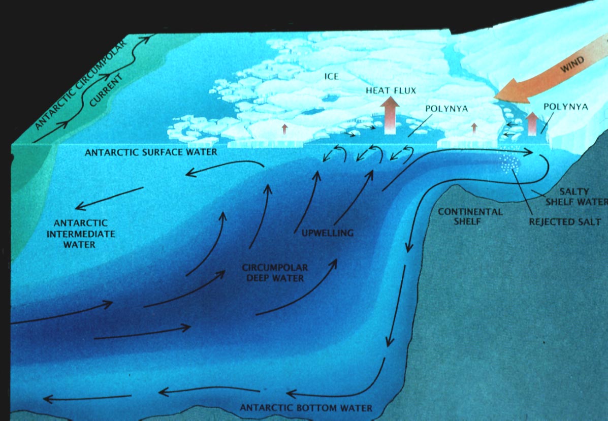
In autumn when the ice cover is expanding, the ice acts as a distillation system, separating sea water into low salinity ice and high salinity brine, which sinks and increases the density of Antarctic Bottom Water, a globally distributed water mass. In winter, during its maximum extent, the ice shuts down the exchange of heat between the ocean and the atmosphere, lowering the surface air temperature by as much as 30°F and increasing the reflectivity (albedo) of the surface. In spring, melting releases microbes and plankton that had been growing in the ice and seeds of phytoplankton bloom. In summer it provides a breeding place for seals. For most of the year the transition zone from ice to open water is one of enhanced biological activity, where birds, seals, and whales congregate to feed. The schematic (© Scientific American 1988, after Gordon and Comiso, 1988) illustrates these actions.
The extent of the Antarctic sea ice has been closely tracked since 1973 from satellite-based sensors that measure the microwave energy emitted by the surface. Open water and sea ice appear very different in the microwave band, and therefore the ice edge can be established very precisely. There has been a slight decrease in the maximum extent of sea ice during the period of record, consistent with a slight climatic warming over the past 25 years. These microwave observations are our only source of information about the Weddell polynya, a large (over 100,000 square miles) area of open water surrounded by sea ice that maintained itself from 1974 to 1976 within the Weddell Sea. It has not been observed since, although evidence has been accumulated about the conditions that probably produced the polynya. Exhibits 44 and 45, prepared by NASA's Goddard Space Flight Center, show the annual minimum and maximum extent of the sea ice in February and September 1974.
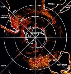
Exhibit 46
Satellite image of ocean color showing phytoplankton blooms, likely sites of biologically mediated flux of carbon dioxide between the atmosphere and the ocean. Carbon dioxide is the most important human-produced greenhouse gas contributing to global warming. To understand or predict global change, the amounts and the rates of carbon dioxide entering and leaving the atmosphere must be determined. The ocean is one of two major sinks, or removers, of atmospheric carbon dioxide (the terrestrial biosphere is the other one). Most oceanic carbon dioxide uptake occurs between 30°S latitude and Antarctica the southern ocean. But the magnitude of this downward flux, or flow, is difficult to quantify with present knowledge.
The southern ocean is the fourth regional experiment of a U.S. contribution to an international program the Joint Global Ocean Flux Study (JGOFS) that is tracing the flow of carbon through the ocean's intertwined chemical, biological, and geological pathways. This work follows other regional experiments in the North Atlantic, the equatorial Pacific, and the Arabian Sea. While each region was chosen for its distinctive oceanic and climatic setting, the southern ocean is unique because its very cold surface allows very high values of dissolved carbon dioxide and because it facilitates vertical convection to the ocean bottom. Climate change models not only show that most of the global oceanic uptake of carbon dioxide occurs in the southern ocean; they also show that the southern ocean flux has the greatest sensitivity to biological variations.
The U.S. Antarctic Program research icebreaker Nathaniel B. Palmer is supporting the southern ocean research. By the end of March 1998, Palmer will have made seven cruises in less than 2 years in support of the Antarctic Environment and Southern Ocean Process Study (AESOPS), a major JGOFS experiment. More than 40 principal investigators will have studied processes including the exchange of gaseous carbon dioxide between the atmosphere and the ocean, the uptake of carbon by phytoplankton blooms, the sinking of organic and inorganic carbon-based matter to the ocean bottom, and the sequestering of carbon within the bottom sediment. Image © Science 1993 after C.W. Sullivan et al.
In another area of Antarctic research, over the last 20 years research teams have collected about 16,000 meteorites representing many different meteorite classes. On the otherwise light-colored background of the ice sheet, meteorites are easy to observe, making collection relatively easy. Also, dynamic processes of the ice sheet, especially near the Transantarctic Mountains and other obstructions, cause meteorites which fell over the last several million years to accumulate at a relatively high density in slow-flowing ablation zones on the ice sheet. Further, the cold, dry environment preserves meteoriteswhich have in fact impacted the Earth's surface.
Meteorites offer important clues to the origin of the solar system and to active solar system processes. For example, scientists determined the ages of Earth and of the early condensation of the solar system from meteorite studies. Also, an emerging area of meteorite research focuses on minute particles of diamonds and other minerals, formed at high temperatures and pressure that are found in ordinary chondritic meteorites and may represent products of stellar processes that predate our solar system.
In 1984, the Antarctic Search for Meteorites program discovered an unusual meteorite in a region of blue ice in the Allan Hills. After several years of research, planetary scientists recognized that this meteorite had originated on the planet Mars and been ejected to the Earth during a Martian collision with some other object. The presence in this meteorite of carbonate minerals, often associated with fluids, offers clues to past environmental conditions on Mars. Recently, an interdisciplinary team of scientists suggested that the presence of these carbonate minerals, along with complex hydrocarbon molecules also found in the meteorite, may be evidence of life on Mars some 3.6 billion years ago, although other researchers indicate that the carbonates formed at 1150°F in the absence of water, conditions not amenable to life as we know it.
Biological studies in the Antarctic also show how living things adapt to one of the harshest climates on Earth. Understanding the genetic and physical basis for the great adaptations of Antarctic life is revealing fundamental insights to biological processes, and is likely to prove useful to humans (Exhibits 47, 48, and 49).
Exhibits 47-49
Life in the Extreme. Knowledge about extreme and unusual environments that are home to microbial life has expanded rapidly in the last decade. These environments, ranging from icy polar seas and dry polar deserts to hot deep-sea hydrothermal vents, may be analogs to ancient environments on Earth and on other planets. Only a fraction of these systems has been studied; knowledge of them will help us understand the diversity of microbial life, its biochemical adaptations enabling survival, and the range of physical and chemical conditions in which life can survive and even flourish.
The Antarctic offers unique opportunities for study of life in environments that are at the limits of the planet's cold, darkness, and dryness. In them, the energy available to support life is among the lowest levels on Earth. Here are three examples, chosen from many:
Exhibit 47
The outer few sixteenths of an inch of some rocks in the cold desert of the McMurdo Dry Valleys creates microclimates with just enough above-freezing days per year and just enough moisture that minute spaces between grains are home to organisms. These organisms are active enough to contribute to weathering of the rock surface, but they appear to be on the limit of their capability and are dormant most of the year. Here, an opened section of Beacon Sandstone from Linnaeus Terrace (Dry Valleys) shows layers of algae, fungi, and bacteria (photo courtesy of E. Imre Friedman, Florida State University).
Exhibit 48
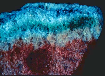
The perennially ice-covered lakes of the McMurdo Dry Valleys harbor communities of cyanobacteria that appear to thrive in stratified, saline water well below 32°F and sometimes in brine pockets in the ice cover.


Exhibit 49
The undersurface of sea ice has rich algal blooms. The color inset is a photomicrograph of chains of sea ice algae with fluorescent stain to reveal protein (red) and lipid (yellow) content of living cells. The other inset shows bacteria from sea ice at greater magnification in a scanning electron microscope image (photos courtesy of C. W. Sullivan, National Science Foundation).
A very exciting opportunity that can be developed is an application of molecular biology techniques to determine the biological history of the Earth, at the microbiological level, that is embedded in ice and sediment cores. With the ability to extract any nucleic acids that may be present, followed by sequencing, fingerprinting, etc., it should be possible to learn how life has changed with the Antarctic environment.
In an entirely different area of research, biomedical studies in Antarctica, and especially at the South Pole, usually in collaboration with NASA, have helped understand the physiology and psychology of living in the isolated environment of the Antarctic.
Antarctica has not always been glaciated. Indeed, 80 million years ago the coastal regions of Antarctica supported lush, temperate forests that were inhabited by a wide diversity of animals. At that time the continent was situated at a latitude similar to that of southern South America today. As the continent drifted toward the south away from the other Gondwana continents, insolation diminished and Antarctica's climate cooled. The evolutionary changes of plants and animals living on the continent and trying to adapt to these more harsh conditions are among the most spectacular and poorly understood paleontological events in Earth's recorded history. There is still much to learn about the evolution of the Antarctic continent, the ice sheet, and the organisms that have lived or continue to live there.
With the rich history of the discoveries emanating from Antarctic research over the past 50 years, as well as their frequent relevance to human well-being on Earth through improved understanding of weather, climate, ocean circulation, etc., Antarctica truly affords a unique laboratory for the conduct of science.
Human activity in the Antarctic began as a quest for exploration, for economic gain, and for scientific knowledge. These goals were reflected in the early Antarctic exploration in the 19th century and the entry into force of the Antarctic Treaty in 1961. Interest in Antarctica now also reflects humankind's expanding influence upon and awareness of the environment.
Antarctica is one of the few remaining nearly pristine sites in the world, and is certainly by far the largest such site. Antarctica is particularly vulnerable to some types of environmental change, notably those that would require biological activity for reversal or amelioration. Pollutants that would be readily biodegradable elsewhere can have very long lifetimes in the Antarctic environment, increasing the possibility of long-term alteration through human activities.
Two treaties have already been put in place to extend the original Antarctic Treaty to include preservation concerns. The Convention for the Conservation of Antarctic Seals took effect in 1978, and the Convention on the Conservation of Antarctic Marine Living Resources took effect in 1982. The Antarctic Treaty together with the recommendations and measures adopted under it and the Seals and Marine Living Resources Conventions have collectively become known as the Antarctic Treaty System.
To enhance protection of the Antarctic environment, the Antarctic Treaty parties in 1991 adopted the Protocol on Environmental Protection to the Antarctic Treaty, designating Antarctica as a natural reserve and setting forth environmental protection principles to be applied to all human activities in Antarctica, including the conduct of science, tourism, and fishing. The Protocol has been signed by all of the 26 Consultative Party nations to the Antarctic Treaty, and will enter into force after the 26 nations have deposited their instruments of ratification, acceptance, approval, or accession.
The U.S. has taken a number of steps to implement the Protocol. Aggressive environmental measures have been introduced into the USAP under the Safety, Environment, and Health Initiative, including removal of all solid wastes and institution of an extensive recycling program at U.S. stations. The USAP has taken a science-based approach to environmental assessment in which careful measurements of environmental parameters are used to monitor changes and evaluate the need for additional protection measures. Thus, U.S. policy currently reflects not only geopolitical and scientific concerns, but also a position of leadership in the international stewardship of the Antarctic environment.