
All Images
News Release 15-012
Monster hurricanes struck U.S. Northeast during prehistoric periods of ocean warming
Scientists find clues in sediment deposits on Cape Cod
This material is available primarily for archival purposes. Telephone numbers or other contact information may be out of date; please see current contact information at media contacts.
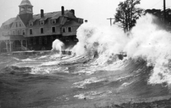
Waves crashed ashore in Woods Hole, Mass., during a 1938 hurricane.
Credit: WHOI
Download the high-resolution JPG version of the image. (1.2 MB)
Use your mouse to right-click (Mac users may need to Ctrl-click) the link above and choose the option that will save the file or target to your computer.
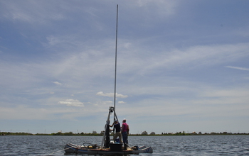
Scientists collect a sediment core; the sediment shows intense storms going back 2,000 years.
Credit: WHOI
Download the high-resolution JPG version of the image. (3.6 MB)
Use your mouse to right-click (Mac users may need to Ctrl-click) the link above and choose the option that will save the file or target to your computer.
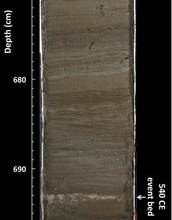
Sediment core section; light-colored sand at 22.7 feet down is evidence of an intense past storm.
Credit: Jeffrey Donnelly, WHOI
Download the high-resolution JPG version of the image. (355.0 KB)
Use your mouse to right-click (Mac users may need to Ctrl-click) the link above and choose the option that will save the file or target to your computer.

Home in Union Beach, N.J., destroyed by a Hurricane Sandy storm tide in 2012.
Credit: Richard Sullivan, WHOI
Download the high-resolution JPG version of the image. (2.9 MB)
Use your mouse to right-click (Mac users may need to Ctrl-click) the link above and choose the option that will save the file or target to your computer.
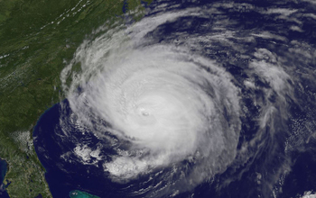
Satellite view of Hurricane Earl as it threatens the U.S. East Coast in 2010.
Credit: NASA
Download the high-resolution JPG version of the image. (610.2 KB)
Use your mouse to right-click (Mac users may need to Ctrl-click) the link above and choose the option that will save the file or target to your computer.
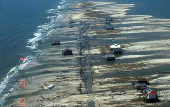
Aerial image of Dauphin Island, Ala., following Hurricane Katrina in 2005.
Credit: USGS
Download the high-resolution JPG version of the image. (285.1 KB)
Use your mouse to right-click (Mac users may need to Ctrl-click) the link above and choose the option that will save the file or target to your computer.