
All Images
News Release 13-203
NSF supports collaborative cyber-enabled research to advance sustainability
CyberSEES program awards $12.5 million for interdisciplinary research in energy, agriculture and environmental management
This material is available primarily for archival purposes. Telephone numbers or other contact information may be out of date; please see current contact information at media contacts.
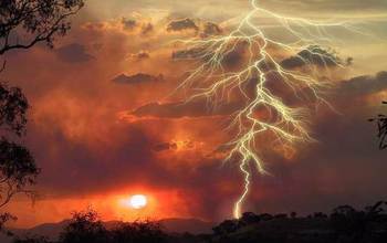
Many ecosystems exhibit spatially-spreading processes that stakeholders would like to manage to either promote or prevent. For wildland fire, one seeks to promote the spread of low-intensity ground fires that prevent the buildup of dangerous fuels while preventing the spread of high-intensity crown fires that destroy endangered species habitat and valuable timber. Researchers from Oregon State University are developing new algorithms that will work with ecosystem simulators and address the risk of catastrophic outcomes such as species extinction or catastrophic wildfires.
Credit: John D. Walstad, Oregon State University.
Download the high-resolution JPG version of the image. (33.8 KB)
Use your mouse to right-click (Mac users may need to Ctrl-click) the link above and choose the option that will save the file or target to your computer.
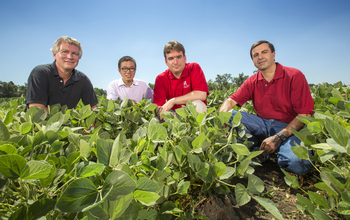
A University of Nebraska-Lincoln team led by Mehmet Can Vuran is exploring how best to commercialize a new wireless sensor system that will help farmers better manage irrigation water applications to conserve water, reduce costs and improve crop yields. The commercialization team, from left, includes: computer scientist Stephen Reichenbach, doctoral student Xin Dong, Vuran and biological systems engineer Suat Irmak. Vuran developed the wireless sensor system with support from NSF through CAREER, Innovation Corps, SBIR Phase 1 and CyberSEES Type 1 awards.
Credit: Copyright: University of Nebraska Board of Regents
Photo credit: Craig Chandler, University of Nebraska-Lincoln
Download the high-resolution JPG version of the image. (21.0 MB)
Use your mouse to right-click (Mac users may need to Ctrl-click) the link above and choose the option that will save the file or target to your computer.
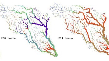
Flow and depth modeling during a two-week rainstorm for 15000 km of river in the Guadalupe and San Antonio River basin (Texas). Line width varies with flow rate, line color varies with flow depth. Modeling was conducted with the cross-disciplinary Simulation Program for River Networks (SPRINT), which applies methods developed for VLSI microprocessor design as a basis for addressing the challenges in dynamic modeling of large river basins.
Credit: Ben R. Hodges, University of Texas at Austin
Download the high-resolution JPG version of the image. (118.8 KB)
Use your mouse to right-click (Mac users may need to Ctrl-click) the link above and choose the option that will save the file or target to your computer.
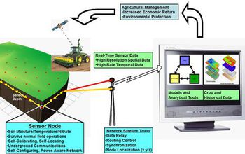
The nutrient needs of crops depend heavily on the soil properties (moisture, temperature, nutrients and SOM), climactic conditions and historical crop management data. Innovations are required in reliable, robust and affordable sensing of the soil properties and the understanding of Crop Growth versus N-Cycling. Researchers from Iowa State are addressing these through the development of a network of in-situ, wireless soil moisture and nutrient sensors capable of self-calibrating, self-localizing and energy-conserving/energy-harvesting.
Credit: R. Kumar (ECE & CS), L. Dong and R. Weber (ECE), M. Castellano and F. Miguez (Agronomy)
Iowa State University, Ames, IA
Download the high-resolution JPG version of the image. (87.6 KB)
Use your mouse to right-click (Mac users may need to Ctrl-click) the link above and choose the option that will save the file or target to your computer.