
All Images
News Release 12-055
First-ever Use of Airborne Resistivity System in Antarctica Allows Researchers to Look Beneath Surface in Untapped Territories
NSF partners with international team to gather new information on hidden environments and past climate conditions in Antarctica
This material is available primarily for archival purposes. Telephone numbers or other contact information may be out of date; please see current contact information at media contacts.
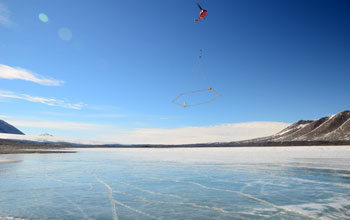
NSF funded and inaugural use of SkyTEM techonology prepares to map topography at Lake Fryxell on the continent of Antarctica.
Credit: Lars Jensen
Download the high-resolution JPG version of the image. (4 MB)
Use your mouse to right-click (Mac users may need to Ctrl-click) the link above and choose the option that will save the file or target to your computer.
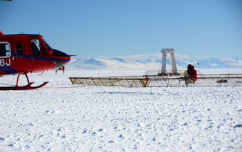
Helicopter preparing to launch NSF funded SkyTEM mapping technology on the sea ice in Antarctica.
Credit: Lars Jensen
Download the high-resolution JPG version of the image. (5.6 MB)
Use your mouse to right-click (Mac users may need to Ctrl-click) the link above and choose the option that will save the file or target to your computer.

Close up view of helicopter deploying NSF-funded technology to map topography in Antarctica for better research capabilities by scientists.
Credit: SkyTEM technology maps topography in Antarctica for the first time.
Download the high-resolution JPG version of the image. (4.5 MB)
Use your mouse to right-click (Mac users may need to Ctrl-click) the link above and choose the option that will save the file or target to your computer.

Image looking down from helicopter to mapping device in Antarctica. This equipment, used for the first time ever in Antarctica, enables researchers to study microbial ecosystems in sub-glacial environments.
Credit: Paul Murphy
Download the high-resolution JPG version of the image. (4.2 MB)
Use your mouse to right-click (Mac users may need to Ctrl-click) the link above and choose the option that will save the file or target to your computer.