
All Images
News Release 12-065
Scientists Find Slow Subsidence of Earth's Crust Beneath the Mississippi Delta
But Gulf Coast sea-level rise rate five times higher now than in pre-industrial times
This material is available primarily for archival purposes. Telephone numbers or other contact information may be out of date; please see current contact information at media contacts.
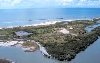
Geoscientists report new findings on sea level rise and coastal subsidence in Louisiana.
Credit: NOAA
Download the high-resolution JPG version of the image. (348 KB)
Use your mouse to right-click (Mac users may need to Ctrl-click) the link above and choose the option that will save the file or target to your computer.
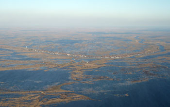
Aerial view of Delacroix, Louisiana, mostly abandoned due to sea-level rise and wetland loss.
Credit: Tor Törnqvist
Download the high-resolution JPG version of the image. (3 MB)
Use your mouse to right-click (Mac users may need to Ctrl-click) the link above and choose the option that will save the file or target to your computer.
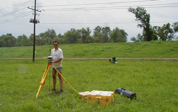
Torbjörn Törnqvist determines the elevation of a GPS-antenna in the Mississippi Delta.
Credit: Juan Gonzalez
Download the high-resolution JPG version of the image. (203 KB)
Use your mouse to right-click (Mac users may need to Ctrl-click) the link above and choose the option that will save the file or target to your computer.
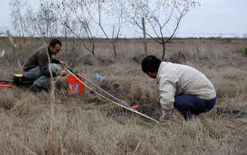
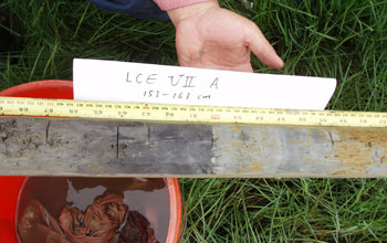
Scientists studying coastal subsidence look at a core section from the study area.
Credit: Juan Gonzalez
Download the high-resolution JPG version of the image. (2.3 MB)
Use your mouse to right-click (Mac users may need to Ctrl-click) the link above and choose the option that will save the file or target to your computer.
Dark gray wetland soil that formed some 3,000 years ago; it offers a view of past sea level.
Credit: Tor Törnqvist
Download the high-resolution JPG version of the image. (1.1 MB)
Use your mouse to right-click (Mac users may need to Ctrl-click) the link above and choose the option that will save the file or target to your computer.

Storm surge on a Louisiana highway shows the effects of rising sea levels.
Credit: NOAA
Download the high-resolution JPG version of the image. (746 KB)
Use your mouse to right-click (Mac users may need to Ctrl-click) the link above and choose the option that will save the file or target to your computer.