
All Images
News Release 11-172
NSF Ocean Observatories Initiative Streams Live Video of Undersea Volcano
Oceanographers investigate aftermath of seafloor volcanic eruption on VISIONS '11 expedition
This material is available primarily for archival purposes. Telephone numbers or other contact information may be out of date; please see current contact information at media contacts.
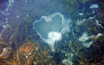
This image looks into the subsurface at Axial Seamount and shows a "snowblower" vent, a collapsed lobate lava flow about 1 meter (3 feet) across with white materials (bacterial mats and biofilm materials that coat the surfaces) thriving in nutrient-rich waters that are slightly above ambient (2 degrees C) temperature. White, dense accumulations of filamentous bacteria surround the snowblower.
Credit: Canadian Scientific Submersible Facility and the University of Washington
Download the high-resolution JPG version of the image. (1000 KB)
Use your mouse to right-click (Mac users may need to Ctrl-click) the link above and choose the option that will save the file or target to your computer.
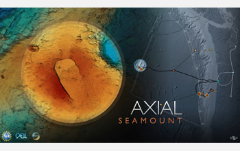
Axial Seamount on the Juan de Fuca Ridge is the site of surveys during the OOI VISIONS '11 cruise.
Credit: Center for Environmental Visualization and OOI-RSN program, University of Washington
Download the high-resolution JPG version of the image. (752 KB)
Use your mouse to right-click (Mac users may need to Ctrl-click) the link above and choose the option that will save the file or target to your computer.
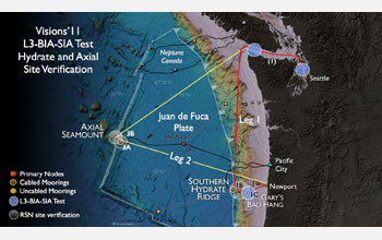
VISIONS '11 cruise track/work areas for installation of NSF OOI regional cabled network component.
Credit: Center for Environmental Visualization and OOI-RSN program, University of Washington
Download the high-resolution JPG version of the image. (127 KB)
Use your mouse to right-click (Mac users may need to Ctrl-click) the link above and choose the option that will save the file or target to your computer.

Oscar Schofield and Scott Glenn, oceanographers onshore in the Rutgers University Institute of Marine and Coastal Sciences, watch the VISIONS '11 live video feed from Axial Seamount on the display wall in the Coastal Ocean Observation Lab (COOL) at the institute.
Credit: Coastal Ocean Observation Lab, Rutgers University, Institute of Marine and Coastal Sciences
Download the high-resolution JPG version of the image. (986 KB)
Use your mouse to right-click (Mac users may need to Ctrl-click) the link above and choose the option that will save the file or target to your computer.
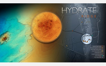
Hydrate Ridge, an area of gas hydrate deposits located off Oregon, is an OOI VISIONS '11 site.
Credit: Center for Environmental Visualization and OOI-RSN program, University of Washington
Download the high-resolution JPG version of the image. (567 KB)
Use your mouse to right-click (Mac users may need to Ctrl-click) the link above and choose the option that will save the file or target to your computer.
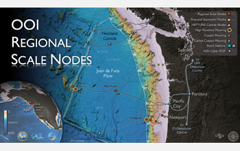
NSF's OOI regional cabled network will carry electrical power and telecommunications bandwidth.
Credit: Center for Environmental Visualization and OOI-RSN program, University of Washington
Download the high-resolution JPG version of the image. (776 KB)
Use your mouse to right-click (Mac users may need to Ctrl-click) the link above and choose the option that will save the file or target to your computer.