
All Images
News Release 11-063
Extra-Cold Winters in Northeastern North America and Northeastern Asia?
Warm water off continents' eastern coasts to blame
This material is available primarily for archival purposes. Telephone numbers or other contact information may be out of date; please see current contact information at media contacts.
Snow cover over North America and Europe in March, 2003, as imaged by a satellite instrument.
Credit: NASA/Goddard Space Flight Center Scientific Visualization Studio; George Riggs (NASA/SSAI)
Download the high-resolution JPG version of the image. (328 KB)
Use your mouse to right-click (Mac users may need to Ctrl-click) the link above and choose the option that will save the file or target to your computer.

The Gulf Stream flows northward along the Eastern United States then diverges out into the Atlantic Ocean.
Credit: NOAA
Download the high-resolution JPG version of the image. (366 KB)
Use your mouse to right-click (Mac users may need to Ctrl-click) the link above and choose the option that will save the file or target to your computer.

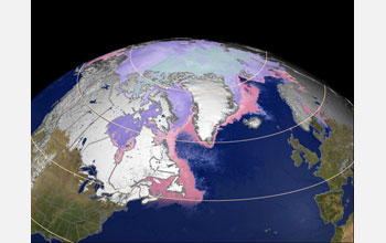
Sea-surface temperatures off Eastern North America; purple = freezing temperature of ocean water.
Credit: NASA
Download the high-resolution JPG version of the image. (1.5 MB)
Use your mouse to right-click (Mac users may need to Ctrl-click) the link above and choose the option that will save the file or target to your computer.

Surface temperature deviation averaged over northern hemisphere winter months and across 40 years.
Credit: Tapio Schneider/Yohai Kaspi
Download the high-resolution JPG version of the image. (193 KB)
Use your mouse to right-click (Mac users may need to Ctrl-click) the link above and choose the option that will save the file or target to your computer.

Blue colors in the southern hemisphere (summer there) show ocean heating; red colors, ocean heat loss. Strong heating of the atmosphere from the ocean off the east coasts of America and Asia is visible.
Credit: Tapio Schneider/Yohai Kaspi
Download the high-resolution JPG version of the image. (188 KB)
Use your mouse to right-click (Mac users may need to Ctrl-click) the link above and choose the option that will save the file or target to your computer.

Scientists have developed a new theory of how warm regions in the ocean lead to atmospheric cooling to their west. In these simulations, the northern hemisphere is perturbed with a constant localized heating at the ocean surface (seen as the redder triangular patch in the atmosphere). As a reference case the southern hemisphere is perturbed with the same amount of heating spread out in all longitudes. In these idealized simulations there is no seasonal cycle.
Credit: Yohai Kaspi
Download the high-resolution GIF version of the image. (11.9 MB)
Use your mouse to right-click (Mac users may need to Ctrl-click) the link above and choose the option that will save the file or target to your computer.