
All Images
News Release 09-094
High Human Impact Ocean Areas Along U.S. West Coast Revealed
Climate change, fishing and commercial shipping top list of threats
This material is available primarily for archival purposes. Telephone numbers or other contact information may be out of date; please see current contact information at media contacts.
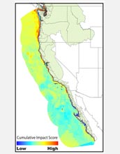
Scientists have developed a map showing West Coast ocean areas most affected by humans.
Credit: Ben Halpern/NCEAS
Download the high-resolution JPG version of the image. (1.5 MB)
Use your mouse to right-click (Mac users may need to Ctrl-click) the link above and choose the option that will save the file or target to your computer.

Satellite map of California shore, among the most human-affected areas of the West Coast.
Credit: NASA
Download the high-resolution JPG version of the image. (212 KB)
Use your mouse to right-click (Mac users may need to Ctrl-click) the link above and choose the option that will save the file or target to your computer.

U.S. West Coast fish populations are heavily impacted by human activities.
Credit: NOAA
Download the high-resolution JPG version of the image. (47 KB)
Use your mouse to right-click (Mac users may need to Ctrl-click) the link above and choose the option that will save the file or target to your computer.