
All Images
News Release 09-075
As World Warms, Water Levels Dropping in Major Rivers
Colorado, Yellow, Ganges, Niger among those rivers affected
This material is available primarily for archival purposes. Telephone numbers or other contact information may be out of date; please see current contact information at media contacts.

The Colorado River is among rivers worldwide that have been affected by a warming Earth.
Credit: U.S. Geological Survey
Download the high-resolution JPG version of the image. (116 KB)
Use your mouse to right-click (Mac users may need to Ctrl-click) the link above and choose the option that will save the file or target to your computer.
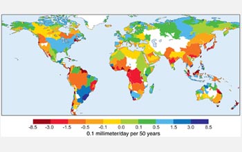
River flow trends worldwide between 1948 and 2004 show that many rivers have lower flows.
Credit: Courtesy Journal of Climate, UCAR
Download the high-resolution JPG version of the image. (505 KB)
Use your mouse to right-click (Mac users may need to Ctrl-click) the link above and choose the option that will save the file or target to your computer.
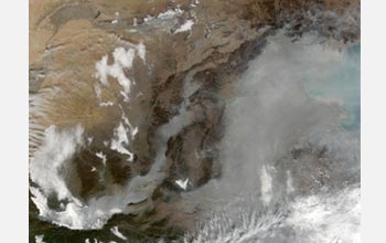
China's Yellow River, shown in this satellite image, has decreased water flow.
Credit: NASA
Download the high-resolution JPG version of the image. (672 KB)
Use your mouse to right-click (Mac users may need to Ctrl-click) the link above and choose the option that will save the file or target to your computer.
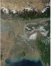
The Ganges River pours sediment into the Bay of Bengal; the river's water levels are changing.
Credit: NASA
Download the high-resolution JPG version of the image. (1.1 MB)
Use your mouse to right-click (Mac users may need to Ctrl-click) the link above and choose the option that will save the file or target to your computer.