
All Images
Media Advisory 07-005
National Science Foundation Sponsors AAAS Annual Conference Workshops
Workshops focus on advances in wireless and grid computing for research applications
This material is available primarily for archival purposes. Telephone numbers or other contact information may be out of date; please see current contact information at media contacts.
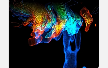
The image shows earthquake modeling beneath Southern California, part of the National Science Foundation's TeraGrid project. The warmer red and yellow colors indicate regions of compression, while the cooler blue and green colors show regions of dilation. Faint yellow (faults), red (roads), and blue (coast-line) lines add geographical context.
Credit: Marcus Thiebaux, Information Sciences Institute, USC
Download the high-resolution JPG version of the image. (1.1 MB)
Use your mouse to right-click (Mac users may need to Ctrl-click) the link above and choose the option that will save the file or target to your computer.