
All Images
News Release 99-021
Nuclear Submarine Puts to Sea to Serve Science
This material is available primarily for archival purposes. Telephone numbers or other contact information may be out of date; please see current contact information at media contacts.
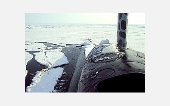
The bridge of the USS Hawkbill at Scientific Ice Expedition '98 after breaking through the ice. SCICEX '99 was conducted aboard USS Hawkbill (SSN 666), which was able to travel almost at will under the ice, making it a unique platform for a sophisticated sonar system dubbed the Seafloor Characterization and Mapping Pods (SCAMP).
Credit: Dale Chayes of the Lamont-Doherty Earth Observatory at Columbia University
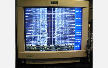
A computer displays sonar information on board a U.S. Navy submarine as part of Scientific Ice Expedition (SCICEX) '99. SCICEX '99 was conducted aboard USS Hawkbill (SSN 666), which was able to travel almost at will under the ice, making it a unique platform for a sophisticated sonar system dubbed the Seafloor Characterization and Mapping Pods (SCAMP).
Credit: Dale Chayes of the Lamont-Doherty Earth Observatory at Columbia University

The USS Hawkbill at Scientific Ice Expedition '98 after breaking through the ice. SCICEX '99 was conducted aboard USS Hawkbill (SSN 666), which was able to travel almost at will under the ice, making it a unique platform for a sophisticated sonar system dubbed the Seafloor Characterization and Mapping Pods (SCAMP).
Credit: Dale Chayes of the Lamont-Doherty Earth Observatory at Columbia University
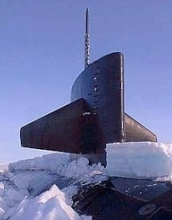
The sail of the USS Hawkbill at Scientific Ice Expedition '98 after breaking through the ice. SCICEX '99 was conducted aboard USS Hawkbill (SSN 666), which was able to travel almost at will under the ice, making it a unique platform for a sophisticated sonar system dubbed the Seafloor Characterization and Mapping Pods (SCAMP).
Credit: Dale Chayes of the Lamont-Doherty Earth Observatory at Columbia University
Download the high-resolution JPG version of the image. (36 KB)
Use your mouse to right-click (Mac users may need to Ctrl-click) the link above and choose the option that will save the file or target to your computer.