
Multimedia Gallery
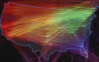
This visualization shows Internet connections in the United States.
A visualization of Internet connections in the United States. The lines represent connections between routers in major urban areas throughout the country. From its humble beginnings in the academic research community to its current state, the Internet's infrastructure grew in a relatively short period of time as private sector providers scrambled to meet the rising public demand for greater access and band width. This growth will continue into the foreseeable future as the nature of the network evolves and more devices such as cellular phones, PDAs and even common appliances are brought online.
Credit: Map by Zina Deretsky, National Science Foundation, adapted from maps by Chris Harrison, Human-Computer Interaction Institute Carnegie Mellon University, www.chrisharrison.net
Images credited to the National Science Foundation, a federal agency, are in the public domain. The images were created by employees of the United States Government as part of their official duties or prepared by contractors as "works for hire" for NSF. You may freely use NSF-credited images and, at your discretion, credit NSF with a "Courtesy: National Science Foundation" notation.
Additional information about general usage can be found in Conditions.
Also Available:
Download the high-resolution JPG version of the image. (4.6 MB)
Use your mouse to right-click (Mac users may need to Ctrl-click) the link above and choose the option that will save the file or target to your computer.
Related story: When the Country Called: How a Team of Academic Experts Contributed to the President's Cyberspace Review