Multimedia Gallery
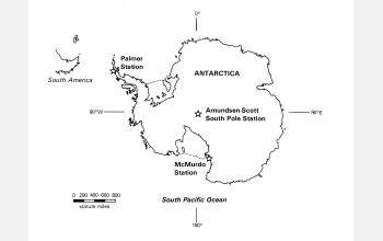
Map showing site of U.S. research stations on Antarctica
Antarctica, the world's coldest continent and site of a broad range of global geoscience research. This map indicates the three U.S. research stations, which are run by the National Science Foundation's U.S. Antarctic Program (USAP).
In addition to maintaining three U.S. research stations on the continent, USAP supports research projects in an array of scientific disciplines, including for example, aeronomy and astrophysics, biology and medicine, geology and geophysics, glaciology, and ocean and climate systems. Outreach such as the Antarctic Artists and Writers program and education programs are also supported. For more information about USAP, visit the program's website Here.
Credit: National Science Foundation
Images and other media in the National Science Foundation Multimedia Gallery are available for use in print and electronic material by NSF employees, members of the media, university staff, teachers and the general public. All media in the gallery are intended for personal, educational and nonprofit/non-commercial use only.
Images credited to the National Science Foundation, a federal agency, are in the public domain. The images were created by employees of the United States Government as part of their official duties or prepared by contractors as "works for hire" for NSF. You may freely use NSF-credited images and, at your discretion, credit NSF with a "Courtesy: National Science Foundation" notation.
Additional information about general usage can be found in Conditions.
Also Available:
Download the high-resolution JPG version of the image. (803 KB)
Use your mouse to right-click (Mac users may need to Ctrl-click) the link above and choose the option that will save the file or target to your computer.

