
Multimedia Gallery
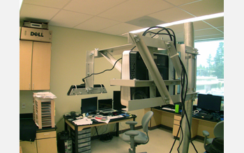
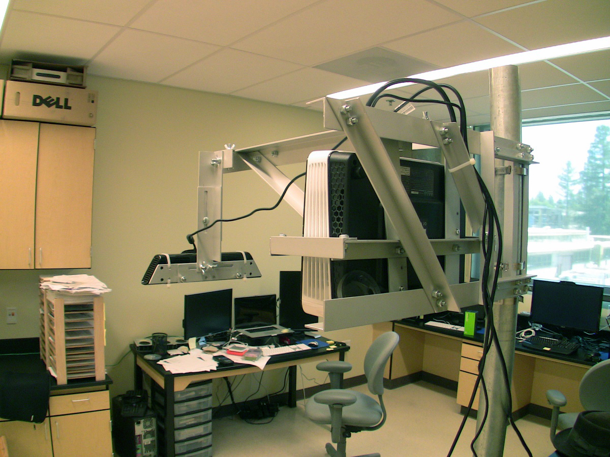
Augmented Reality Sandbox (Image 4)
A view of the projector and Microsoft Kinect 3D camera assembly used to create the "Shaping Watersheds Interactive Sandbox," an augmented reality (AR) sandbox, as seen from behind. Both components can be adjusted individually for optimal calibration. [This is Image 4 in a series of 19 images showing the process involved in creating the AR sandbox from start to finish, and the end product in use. See Image 5.]
More about this image
The AR sandbox was created by the University of California (UC), Davis', Tahoe Environmental Research Center (TERC) and the UC-Davis W.M. Keck Center for Active Visualization in the Earth Sciences (KeckCAVES) as part of the National Science Foundation-supported LakeViz3D project in which researchers create 3D visualization applications to teach Earth science concepts. Partnering institutions include UC-Berkeley's Lawrence Hall of Science and the ECHO Lake Aquarium and Science Center in Burlington, Vermont.
The LakeViz3D project seeks to raise public awareness and increase understanding and stewardship of freshwater lake ecosystems and Earth science processes using immersive, 3D visualizations of lake and watershed processes, supplemented by tabletop science activity stations that can be used, for example, in science centers and museums.
Among the activities developed by LakeViz3D is the "Shaping Watersheds Interactive Sandbox," a hands-on exhibit that combines a real sandbox with virtual topography and water, created using a closed loop of a Microsoft Kinect 3D camera, powerful simulation and visualization software, and a data projector. Users create topography models by shaping real sand, which is then augmented in real time by an elevation color map, topographic contour lines and simulated water. The system teaches geographic, geologic and hydrologic concepts such as how to read a topography map, and the meaning of contour lines, watersheds, catchment areas, levees, etc.
In May 2013, the ECHO Lake Aquarium and Science Center was the first science center to create and share a publicly accessible version of the AR sandbox.
"It's a teaching tool for all ages," said TERC director Geoffrey Schladow. "Usually, when you talk to kids about topography or what a contour line means, they're asleep in 30 seconds. With this exhibit, they're playing around, seeing the topographic map and watching how water flows downhill and where it goes. It becomes a game, and they've done it without really knowing they've learned something."
The sandbox was created by a UC-Davis team, led by KeckCAVES associate research scientist Oliver Kreylos, after being inspired by a video created by a group of Czech researchers who demonstrated in 2011 a prototype of an AR sandbox that used color mapping and a limited form of fluid flow. The team took the basic idea of capturing a sand surface with a 3D camera and projecting a colored image depicting elevation back onto the sand, then added a realistic water simulation and elevation contour lines to make the sandbox look more like a printed topographic map.
Further information about the AR sandbox including videos of the AR process in action is available on Kreylos' website. [Research supported by NSF grant DRL 11-14663.] (Date of Image: 2012-2013)
Credit: Oliver Kreylos, UC-Davis KeckCAVES
Images and other media in the National Science Foundation Multimedia Gallery are available for use in print and electronic material by NSF employees, members of the media, university staff, teachers and the general public. All media in the gallery are intended for personal, educational and nonprofit/non-commercial use only.
Images credited to the National Science Foundation, a federal agency, are in the public domain. The images were created by employees of the United States Government as part of their official duties or prepared by contractors as "works for hire" for NSF. You may freely use NSF-credited images and, at your discretion, credit NSF with a "Courtesy: National Science Foundation" notation.
Additional information about general usage can be found in Conditions.
Also Available:
Download the high-resolution JPG version of the image. (780 KB)
Use your mouse to right-click (Mac users may need to Ctrl-click) the link above and choose the option that will save the file or target to your computer.