
Multimedia Gallery
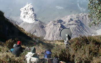
Santiaguito Field Experiment (Image 7)
Doppler radar observations of the regular (hourly) explosions from Santiaguito's Caliente dome as seen by principal investigator Jeffrey Johnson and his research team from their vantage point on the summit of Santa Maria in 2007.
Santiaguito is an active dome that has been growing since 1922 within the crater left by the catastrophic 1902 eruption of Santa Maria plinian eruption (a 6 on the Volcanic Explosivity Index). Plinian eruptions have columns of gas and volcanic ash that extend high into the stratosphere and include such characteristics as ejections of large amounts of pumice and very powerful continuous gas blast eruptions.
In January 2007, Johnson and a multi-institution team of researchers conducted a week-long field experiment that included establishing a manned observation post near the summit of Santa Maria from which eruptions of Santiaguito's Caliente dome can be viewed.
Caliente (summit elevation ~2600 meters) is located approximately 1.2 kilometers below and 2 kilometers to the southwest of the Santa Maria summit. In recent years, Santiaguito has been simultaneously extruding dacitic magma and erupts explosively several tens of times each day. Typically these pyroclastic-laden eruptions originate from diffuse, often concentric fractures distributed about the 200 meter-diameter crater. Plumes are buoyantly driven up to heights of 1 to 2 kilometers. Larger explosions and/or associated lava flow that collapse on the steep slopes of Caliente dome generate pyroclastic flows that are generally confined to the upper reaches of the volcano.
The project by Johnson and the team included coordinated experiments on the volcano with seismic and acoustic sensors (for analysis of earthquakes), infrared video (for study of thermal signals), Doppler radar (for analysis of eruption material velocities), UV absorption imagery (for analysis of gas flux), and high-resolution digital video (from the summit looking straight down into the vent). Simultaneous thermal and UV imagery was obtained from the Santiaguito Observatory. Further information about the data collected during the experiment is available Here.
This research was supported in part by a grant from the National Science Foundation's Division of Earth Sciences (EAR 04-40225). Johnson was with New Mexico Tech earth and environmental sciences department at the time of this research, but is now in the department of geosciences at Boise State University. (Date of Image: 2007) [Image 7 of 7 related images. Back to Image 1.]
Credit: Assistant Professor Jeffrey Johnson, Department of Geosciences, Boise State University
See other images like this on your iPhone or iPad download NSF Science Zone on the Apple App Store.
Images and other media in the National Science Foundation Multimedia Gallery are available for use in print and electronic material by NSF employees, members of the media, university staff, teachers and the general public. All media in the gallery are intended for personal, educational and nonprofit/non-commercial use only.
Images credited to the National Science Foundation, a federal agency, are in the public domain. The images were created by employees of the United States Government as part of their official duties or prepared by contractors as "works for hire" for NSF. You may freely use NSF-credited images and, at your discretion, credit NSF with a "Courtesy: National Science Foundation" notation.
Additional information about general usage can be found in Conditions.
Also Available:
Download the high-resolution JPG version of the image. (1.5 MB)
Use your mouse to right-click (Mac users may need to Ctrl-click) the link above and choose the option that will save the file or target to your computer.