
A Mobile Sensor Web for Polar Ice Sheet Measurements
PRINCIPAL INVESTIGATOR: PRASAD GOGINENI
![]()
“Mobile Sensor Web for Polar Ice Sheet Measurements” is an interdisciplinary research project that brings together engineers and scientists to develop and demonstrate new sensors that will contribute to our understanding of ice sheet behavior and the contributions of the ice sheets to sea level rise. The University of Kansas is the lead institution. Other participants include Haskell Indian Nations University, The Ohio State University, the University of Alaska-Fairbanks, NASA's Jet Propulsion Laboratory, the U.S. Army Cold Regions Research and Engineering Laboratory, the University of Copenhagen, and the Australian Antarctic Division.
The research is multifaceted, involving the development of sensors, wireless communications, intelligent systems, robotics, and ice sheet modeling. The sensors include radars for imaging the ice-bed interface, measuring ice thickness, and mapping internal layers in the ice with a fine resolution of 10 cm or better. As part of this project, research team will develop an autonomous rover for operating radars and an intelligent agent system for selecting optimum radar configuration — bistatic or monostatic — and controlling the rover’s operation.
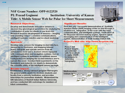
We conducted field tests and experiments to evaluate sensors, a rover, an intelligent system and communication system at Summit Camp on the Greenland ice sheet during two summer field seasons. These field experiments resulted in the first and only successful Synthetic Aperture Radar (SAR) imaging of the ice bed 3 kilometers below (images shown in the slide) . Traditionally, radars for ice sheet studies are operated in altimeter mode at normal incidence, which results in poor resolution in the cross-track direction. On the other hand, a Synthetic Aperture Radar (SAR), which is operated off-vertical, can provide a two-dimensional reflectivity maps with fine resolution (10-30 m) over a swath of a few hundred meters. Radar reflectivity depends on ice sheet topography and dielectric contrast at the ice-bed interface. A wideband SAR can also be operated in interferometric mode to determine topography (slide shows two SAR images obtained in interferometric mode) . Thus we can use SAR data to separate topography and reflectivity effects to determine basal conditions unambiguously. The SAR has great potential to obtain data needed to understand rapid changes of polar ice sheets taking place now. We are preparing sensors and systems for extensive measurements during the 2005 summer in Greenland and later in December 2005-January 2006 in Antarctica.
Developing a communication system for remote field operations in polar regions both for safety and transfer of data is an important goal of the Office of Polar Programs. This is an especially difficult problem because communication satellites constitute the only effective way to transfer data from the polar regions. Unfortunately, most commercial communication satellites that carry high data-rate traffic cannot be accessed from the polar regions. A few specialized polar orbiting satellites, such as Iridium, are the only candidates for use in these regions, and these satellites are mostly narrow-band systems intended for voice communications.
As a part of the research project, we developed and demonstrated a parallel voice-band modem system for transferring data out of the polar regions via the Iridium satellite system. By managing voice-band modems in parallel and properly conditioning the data through a demultiplexing and remultiplexing process, much higher data rates of about 18 kbits/s were achieved using the Iridium system than ever before realized in the field. (The concept is shown in the slide.) This is the first system of its kind, and its capabilities were demonstrated and used to support the expedition’s data collection goals during the field campaign this past summer.
This project has established a strong outreach program, targeting the public, K-12 students, and underrepresented populations to increase awareness of societal issues surrounding the polar regions and increase the number of members of underrepresented groups studying polar science, climate change, robotics, and radar sensors. The project’s web site was chosen in February 2005 by the Eisenhower National Clearinghouse to be included in the "Digital Dozen" — a list of exemplary websites for math and science educators. Native American students and faculty from Haskell Indian Nations University contribute to this project through their GIS laboratory, which this project helped to modernize. In addition, this project is helping to conduct GIS workshops for members of tribal communities.
| Link to the PDF version of this slide. | Link to the text version of this slide. |
![]()
![]()
| Office of Polar Programs SITE MAP! |