
All Images
Research News
Tracking a supercell thunderstorm across the Great Plains

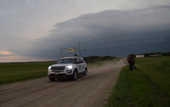
Researchers load instrumentation onto a tracker vehicle before a drone's takeoff.
Credit: Roger Laurence
Download the high-resolution JPG version of the image. (10.2 MB)
Use your mouse to right-click (Mac users may need to Ctrl-click) the link above and choose the option that will save the file or target to your computer.
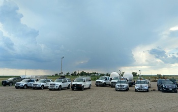
Scientists stage drones and other instruments for project deployment.
Credit: Adam Houston
Download the high-resolution JPG version of the image. (5.5 MB)
Use your mouse to right-click (Mac users may need to Ctrl-click) the link above and choose the option that will save the file or target to your computer.
A drone launching, with a severe thunderstorm in the background.
Credit: Roger Laurence
Download the high-resolution JPG version of the image. (8.6 MB)
Use your mouse to right-click (Mac users may need to Ctrl-click) the link above and choose the option that will save the file or target to your computer.
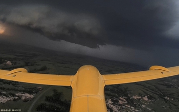
The drone named TTwistor3 approaching a supercell thunderstorm in southern South Dakota.
Credit: Integrated Remote and In-Situ Sensing (IRISS), University of Colorado Boulder
Download the high-resolution 53 version of the image. (906.7 KB)
Use your mouse to right-click (Mac users may need to Ctrl-click) the link above and choose the option that will save the file or target to your computer.
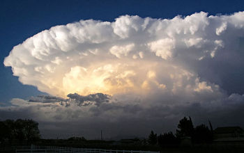
Supercell storms are distinguishable from other thunderstorms by their large-scale rotation.
Credit: Greg Lundeen/Wikimedia Commons
Download the high-resolution JPG version of the image. (56.8 KB)
Use your mouse to right-click (Mac users may need to Ctrl-click) the link above and choose the option that will save the file or target to your computer.