
All Images
Research News
Deeper View Helps Explain Rio Grande Rift
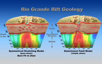
This illustration shows the result of data collected by La RISTRA researchers and reveals the properties of the crust and upper mantle beneath the Rio Grande. From the information, the researchers suspect the pure shear model is the more probable explanation, with a "taffy-like" thinning of the lower crust and the upper crust faulting in many places to produce the rift valley. This scenario is in contrast to the "simple shear" model wherein a single, large detachment fault controls continental rifting.
Credit: Nicolle Rager, NSF
Download the high-resolution JPG version of the image. (504 KB)
Use your mouse to right-click (Mac users may need to Ctrl-click) the link above and choose the option that will save the file or target to your computer.
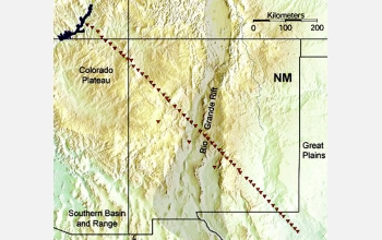
The diagonal line shows the location of seismic instruments used to image the geological structures beneath the Rio Grande Rift. The darkened region through central New Mexico denotes the Rio Grande Rift.
Credit: New Mexico State University
Download the high-resolution JPG version of the image. (839 KB)
Use your mouse to right-click (Mac users may need to Ctrl-click) the link above and choose the option that will save the file or target to your computer.
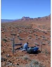
Joe Leon, a former graduate student at New Mexico Tech, is shown servicing a RISTRA seismic station near Monument Valley in Utah.
Credit: New Mexico State University
Download the high-resolution JPG version of the image. (608 KB)
Use your mouse to right-click (Mac users may need to Ctrl-click) the link above and choose the option that will save the file or target to your computer.