text-only page produced automatically by LIFT Text
Transcoder Skip all navigation and go to page contentSkip top navigation and go to directorate navigationSkip top navigation and go to page navigation
National Science Foundation


NSF 07-43, Benchmarks of NSF Innovation

top portion of cover page for the Benchmarks of NSF Innovation, includes illustration of molecule chains above rippling water
Return to Benchmarks index.

UNTANGLING TRAFFIC WITH CELL PHONES

Engineers have developed a system that takes anonymous cell-phone location information and turns it into an illuminated traffic map that identifies congestion in real time. The system takes advantage of the steady stream of positioning cues, untraced signals all cell phones produce whether in use or not, as they seek towers. It is the first traffic-solution technology that monitors patterns on rural roads and city
streets as easily as on highways.

Developed by IntelliOne of Atlanta, Ga., the TrafficAid system could not only help guide drivers around tie-ups, but also tell emergency responders where accidents are or how effectively an evacuation is unfolding by pinpointing clusters of cell phones. Unlike sensors and other equipment along major freeways that are expensive and take years to deploy, this system takes advantage of existing cellular networks in which wireless carriers have already invested billions of dollars, according to NSF awardee and IntelliOne Chief Executive Officer Ron Herman.

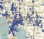
map grid with numerous blue dots scattered

The IntelliOne Roadway Speed Measurement System uses cell phone signals to map roadway speeds for all highways and surface streets where mobile phone coverage exists. The blue dots represent a snapshot of all active mobile phones from a single carrier's network in Tampa, Fla.

Credit: IntelliOne Technologies Corporation.

Expanding the Computational Grid Frontier [Next]


Back to Top of page