
News Release 08-125
Scientists Test System to Forecast Flash Floods along Colorado's Front Range
People near vulnerable creeks, streams, rivers may soon have advance notice
Communities may soon have advance warning of flash floods.
July 22, 2008
This material is available primarily for archival purposes. Telephone numbers or other contact information may be out of date; please see current contact information at media contacts.
People living near vulnerable creeks and rivers along Colorado's Front Range may soon get advance notice of potentially deadly floods, thanks to a new forecasting system being tested this summer by the National Center for Atmospheric Research (NCAR) in Boulder, Colo.
Known as the NCAR Front Range Flash Flood Prediction System, it combines detailed atmospheric conditions with information about stream flows to predict floods along specific streams and catchments.
"The goal is to provide improved guidance about the likelihood of a flash flood event many minutes out to an hour or two before the waters start rising," says NCAR scientist David Gochis, one of the developers of the new forecasting system. "We want to increase the lead time of a forecast, while decreasing the uncertainty about whether a flood will occur."
Funding to create the system came from the National Science Foundation (NSF), which is NCAR's sponsor, as well as the National Oceanic and Atmospheric Administration.
"This project is an excellent example of using basic research findings to improve forecasts important to saving lives," said Cliff Jacobs, program director in NSF's Division of Atmospheric Sciences.
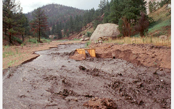
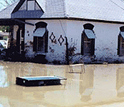
The Front Range, because of its steep topography and intense summer storms, is unusually vulnerable to summertime flash floods. Such floods have claimed the lives of hundreds of people and accounted for hundreds of millions of dollars in damages throughout the region's history.
Flash floods are difficult to predict because they happen suddenly, often the result of heavy cloudbursts that may stall over a particular watershed.
Forecasters can give a few hours' notice that weather conditions might lead to flooding, and radars can detect heavy rain within minutes.
But whether a flood hits a specific river or creek also depends on soil, topographic, and hydrologic conditions that are characteristic to particular watersheds. Thus, emergency managers may not know that a flash flood is imminent until the waters begin to rise.
The goal of the NCAR system is to provide officials at least 30 minutes warning of flash flooding in specific watersheds, and possibly as much as an hour or two.
It is designed to pinpoint whether a particular stream is likely to overflow, as well as forecast the likelihood of flash floods producing events across a larger region.
Scientists will monitor the system's performance each day, tracking potential flood events from Colorado Springs in the south to Fort Collins in the north.
After this summer's test of the system, researchers will evaluate its performance and make improvements as needed.
"This summer is a proof-of-concept test," Gochis says. "If we can show that our system has some reasonable skill in predicting floods, we think officials may become more interested in using it along with their existing suites of tools."
To predict weather events, the system utilizes National Weather Service radar observations of current conditions and short-term computerized weather forecasts. The weather forecasts are generated by NCAR's Weather Research and Forecasting (WRF) model, which produces highly detailed simulations of the local atmosphere.
The system integrates the weather information with datasets about hydrology and terrain. These datasets incorporate information about land surface conditions, such as terrain slope, soil composition and surface vegetation. They also include information on stream flow and channel conditions.
By combining information about the land and the atmosphere, the system can project whether an intense storm is likely to stall over a specific area of the Front Range and how that may impact the flow of water on the ground.
"This new system is unique in that it provides a detailed forecast of the location and duration of a severe storm, as well as the watershed's likely response to the heavy rain," explains NCAR scientist David Yates.
"Since flash floods are complex and fast-moving events, we need to know about both weather and ground conditions in order to predict them."
-NSF-
-
Scientists are testing a new, high-tech system that will better forecast flash floods.
Credit and Larger Version
Media Contacts
Cheryl Dybas, NSF, (703) 292-7734, email: cdybas@nsf.gov
David Hosansky, NCAR, (303) 497-8611, email: hosansky@ucar.edu
The U.S. National Science Foundation propels the nation forward by advancing fundamental research in all fields of science and engineering. NSF supports research and people by providing facilities, instruments and funding to support their ingenuity and sustain the U.S. as a global leader in research and innovation. With a fiscal year 2023 budget of $9.5 billion, NSF funds reach all 50 states through grants to nearly 2,000 colleges, universities and institutions. Each year, NSF receives more than 40,000 competitive proposals and makes about 11,000 new awards. Those awards include support for cooperative research with industry, Arctic and Antarctic research and operations, and U.S. participation in international scientific efforts.
Connect with us online
NSF website: nsf.gov
NSF News: nsf.gov/news
For News Media: nsf.gov/news/newsroom
Statistics: nsf.gov/statistics/
Awards database: nsf.gov/awardsearch/
Follow us on social
Twitter: twitter.com/NSF
Facebook: facebook.com/US.NSF
Instagram: instagram.com/nsfgov