
All Images
News Release 15-099
NSF, National Geospatial-Intelligence Agency support development of new Arctic maps
Comprehensive digital elevation maps to aid researchers
This material is available primarily for archival purposes. Telephone numbers or other contact information may be out of date; please see current contact information at media contacts.

Digital Elevation Models like this depiction of Point Hope, Alaska, will help researchers evaluate how warming in the region is affecting the Arctic.
Credit: Polar Geospatial Center, Ohio State University, Cornell University, DigitalGlobe Inc.
Download the high-resolution JPG version of the image. (1.8 MB)
Use your mouse to right-click (Mac users may need to Ctrl-click) the link above and choose the option that will save the file or target to your computer.
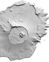
Digital Elevation Models, like this depiction of of Yunaska Island, Alaska, will have a resolution of between 2 and 8 meters.
Credit: Polar Geospatial Center, Ohio State University, Cornell University, DigitalGlobe Inc.
Download the high-resolution JPG version of the image. (3.1 MB)
Use your mouse to right-click (Mac users may need to Ctrl-click) the link above and choose the option that will save the file or target to your computer.