
All Images
News Release 11-138
Scientists on a Mission: Detailed Study of U.S. Southeast Tornadoes
Focus on deadly April 27, 2011, outbreak in Alabama and surrounding states
This material is available primarily for archival purposes. Telephone numbers or other contact information may be out of date; please see current contact information at media contacts.
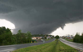
Image of a strong tornado near Arab, Ala., part of the outbreak on April 27, 2011.
Credit: Charles Whisenant
Download the high-resolution JPG version of the image. (2.4 MB)
Use your mouse to right-click (Mac users may need to Ctrl-click) the link above and choose the option that will save the file or target to your computer.

Atmospheric scientist Kevin Knupp works on a lap-top connected to a radiosonde system.
Credit: Kevin Knupp
Download the high-resolution JPG version of the image. (4.5 MB)
Use your mouse to right-click (Mac users may need to Ctrl-click) the link above and choose the option that will save the file or target to your computer.

A special UAH radar instrument shows multiple tornado supercell storms on April 27, 2011.
Credit: Kevin Knupp
Download the high-resolution JPG version of the image. (5.8 MB)
Use your mouse to right-click (Mac users may need to Ctrl-click) the link above and choose the option that will save the file or target to your computer.

The UAH Advanced Radar for Meteorological and Operational Research tracks a tornado.
Credit: Kevin Knupp
Download the high-resolution JPG version of the image. (5 MB)
Use your mouse to right-click (Mac users may need to Ctrl-click) the link above and choose the option that will save the file or target to your computer.

Damage from a tornado in Alabama, on April 27, 2011; the storm carried away this entire house.
Credit: Kevin Knupp
Download the high-resolution JPG version of the image. (4.7 MB)
Use your mouse to right-click (Mac users may need to Ctrl-click) the link above and choose the option that will save the file or target to your computer.

Radar image showing storm circulation associated with 15 or more tornadoes in the Southeastern United States.
Credit: National Weather Service
Download the high-resolution JPG version of the image. (3 MB)
Use your mouse to right-click (Mac users may need to Ctrl-click) the link above and choose the option that will save the file or target to your computer.