
All Images
News Release 06-028
Instruments on Alaska's Augustine Volcano Provide New Insights into Volcanic Processes
This material is available primarily for archival purposes. Telephone numbers or other contact information may be out of date; please see current contact information at media contacts.
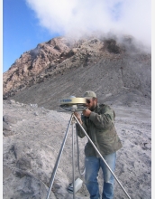
T. Corbett (EarthScope) finishes installation of GPS station AV04 by connecting the choke ring, used to reduce noise in the data, to the steel tripod.
Credit: EarthScope
Download the high-resolution JPG version of the image. (805 KB)
Use your mouse to right-click (Mac users may need to Ctrl-click) the link above and choose the option that will save the file or target to your computer.
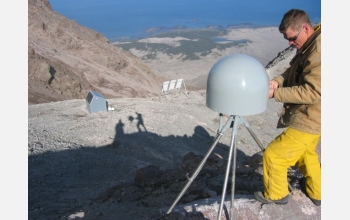
B. Friesen (EarthScope) puts the final touches on the GPS antennae at station AV05, the closest station to the summit of Augustine. AV05 collected valuable data about the volcano until one of the large eruptions on Jan. 13, 2006. It has been missing since the eruption.
Credit: EarthScope
Download the high-resolution JPG version of the image. (93 KB)
Use your mouse to right-click (Mac users may need to Ctrl-click) the link above and choose the option that will save the file or target to your computer.
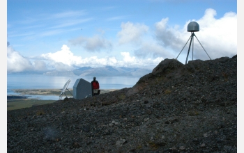
EarthScope GPS station AV01 is installed to the east of the Augustine summit. AV01 has survived the recent eruptions of Augustine and is returning GPS data every hour.
Credit: Earthscope
Download the high-resolution JPG version of the image. (1.2 MB)
Use your mouse to right-click (Mac users may need to Ctrl-click) the link above and choose the option that will save the file or target to your computer.