
Multimedia Gallery
September 17, 2015
Images credited to the National Science Foundation, a federal agency, are in the public domain. The images were created by employees of the United States Government as part of their official duties or prepared by contractors as "works for hire" for NSF. You may freely use NSF-credited images and, at your discretion, credit NSF with a "Courtesy: National Science Foundation" notation.
Additional information about general usage can be found in Conditions.
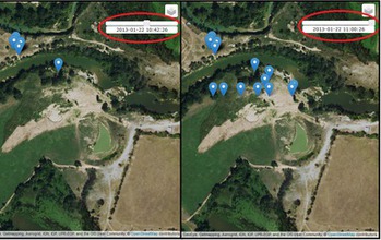
Abygail McMillian created a program that visually displays where and when UAV data was taken.
Abygail McMillian, a student at the University of North Georgia, created a program that visually displays where and when UAV data or any geotagged data was taken. She was a participant in a Research Experiences for Undergraduates (REU) program on Computing for Disasters, sponsored by NSF and led by Robin Murphy.
Credit: CRASAR
Images credited to the National Science Foundation, a federal agency, are in the public domain. The images were created by employees of the United States Government as part of their official duties or prepared by contractors as "works for hire" for NSF. You may freely use NSF-credited images and, at your discretion, credit NSF with a "Courtesy: National Science Foundation" notation.
Additional information about general usage can be found in Conditions.
Also Available:
Download the high-resolution PNG version of the image. (6.2 MB)
Use your mouse to right-click (Mac users may need to Ctrl-click) the link above and choose the option that will save the file or target to your computer.
Related story: Robots to the rescue