
Multimedia Gallery
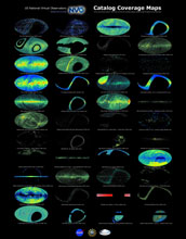
Catalog Coverage Maps
Catalog Coverage Maps
The National Virtual Observatory's "Sky Statistics Service" allows astronomers to get a fast inventory of astronomical objects from various catalogs. These catalogs can be wavelength-based (x-ray sources, radio sources, etc.), phenomena-based (supernova remnants, planetary nebulae, variable stars, quasars, etc.), or may simply show where a telescope has been pointed (HST observation log, ESO observation log, etc.). The Sky Statistics Service also allows astronomers to easily determine regions of overlap between catalogs. These images show the distribution of objects in a sample of the many astronomical catalogs that are accessible through the National Virtual Observatory.
This research was supported by National Science Foundation grant AST 01-22449. (Date of Image: January 2006)
Credit: National Virtual Observatory and California Institute of Technology (http://us-vo.org/)
Images and other media in the National Science Foundation Multimedia Gallery are available for use in print and electronic material by NSF employees, members of the media, university staff, teachers and the general public. All media in the gallery are intended for personal, educational and nonprofit/non-commercial use only.
Images credited to the National Science Foundation, a federal agency, are in the public domain. The images were created by employees of the United States Government as part of their official duties or prepared by contractors as "works for hire" for NSF. You may freely use NSF-credited images and, at your discretion, credit NSF with a "Courtesy: National Science Foundation" notation.
Additional information about general usage can be found in Conditions.
Also Available:
Download the high-resolution TIF version of the image. (48.3 MB)
Use your mouse to right-click (Mac users may need to Ctrl-click) the link above and choose the option that will save the file or target to your computer.