
Multimedia Gallery
Earthscope (Image 2)
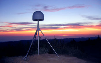
Global positioning system (GPS) station P314, located at Cahto Peak, Calif. The station is part of a GPS cluster that is monitoring transform plate movements in California. The station is on the west side of the Brush Mountain Shear Zone, which is the inferred extension to the Maacama Fault Zone. Data will be compared with stations on the west side of the shear zone to better understand the interplay of faults in the region.
This data is being collected as part of EarthScope, a program that deploys thousands of seismic, GPS and other geophysical instruments to study the structure and evolution of the North American continent and the processes the cause earthquakes and volcanic eruptions. [One of 14 related images. See next image Here.]
More about this Image
In a modern day journey to the center of the Earth, geologists are exploring the structure and evolution of the North American continent at scales from hundreds of kilometers to less than a millimeter--from the structure of a continent, to individual faults, earthquakes and volcanoes. The project is called EarthScope. With approximately $200 million in funding from the National Science Foundation (NSF), EarthScope began development in 2004, and will continue over a five year period. It is expected to operate for an additional 15 years.
EarthScope is using multiple technologies to explore the structure and tectonics of North America. For example, a 4-kilometer deep observatory was drilled directly into the San Andreas Fault to measure the physical conditions under which earthquakes occur there. One of 875 permanent GPS stations has been installed that can measure relative distance changes of less than 0.5 millimeters. EarthScope is one of an eventual network of 400 seismographic stations that will spread across the U.S., making observations at more than 2,000 geographic locations to map the structure and composition of North America. EarthScope also provides unique educational opportunities as a national experiment, with its sensors located at more than 3,000 sites across the U.S. for measuring and observing plate tectonics in real time. For more information, visit the EarthScope website Here.
Credit: Earthscope
See other images like this on your iPhone or iPad download NSF Science Zone on the Apple App Store.
Images and other media in the National Science Foundation Multimedia Gallery are available for use in print and electronic material by NSF employees, members of the media, university staff, teachers and the general public. All media in the gallery are intended for personal, educational and nonprofit/non-commercial use only.
Images credited to the National Science Foundation, a federal agency, are in the public domain. The images were created by employees of the United States Government as part of their official duties or prepared by contractors as "works for hire" for NSF. You may freely use NSF-credited images and, at your discretion, credit NSF with a "Courtesy: National Science Foundation" notation.
Additional information about general usage can be found in Conditions.
Also Available:
Download the high-resolution JPG version of the image. (2.5 MB)
Use your mouse to right-click (Mac users may need to Ctrl-click) the link above and choose the option that will save the file or target to your computer.