
Multimedia Gallery
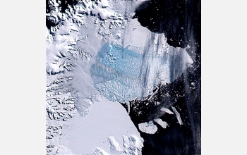
Break up of massive portion of Larsen B ice shelf (Image 4)
One of a series of satellite images of the Antarctic Peninsula record the catastrophic break up of a massive portion of the Larsen B ice shelf, an area larger than the state of Rhode Island, in 2002.
This series of true-color images was created from the MODIS (Moderate Resolution Imaging Spectroradiometer) sensor aboard the Terra satellite platform by combining bands 1, 3 and 4. Resolution of band 1 (red) is 250 meters. Color information in bands 3 (blue) and 4 (green) is at 500M resolution. These images were derived from the National Science Foundation (NSF)-supported Antarctic Glaciological Data Center project (see http://nsidc.org/). The research leading to the creation and interpretation of these images was funded by NASA. [Image 4 in a series of 6 images. See Image 5.]
More about this image:
Researchers are traveling around the globe from the poles to the tropics to glean a better understanding of the world's climate change. They are particularly interested in finding out to what extent the warming we see today is due to human production of greenhouse gases such as carbon dioxide, which traps heat in the atmosphere. In the Antarctic Peninsula, the average annual air temperature has increased about 5 degrees Fahrenheit in the past half century, a huge rise. As a result, many of the peninsula's ice shelves are shrinking. Ice shelves are floating platforms of ice hundreds or even thousands of feet thick that extend many miles from the continent. For example, in just a few short years, almost half of the third largest ice shelf in Antarctica--the Larsen Ice Shelf--has disappeared. The northernmost segment--called Larsen A--has completely melted since the mid-1990s. And the much larger middle segment--Larsen B--shrank rapidly through the late 1990s, then lost most of its remaining mass in February 2002 when a chuck the size of the state of Rhode Island (about 1,250 square miles of ice) broke off and disintegrated.
Is melting of this magnitude an unprecedented event in recent geologic time? NSF's Office of Polar Programs is supporting researchers like Scott Ishman, a paleobiologist and assistant professor of geology at Southern Illinois University, Carbondale, to try and answer this question by determining the history of the Larsen Ice Shelf during the 12,000 years that have passed since the end of the last great ice age. Part of Ishman's research has involved collecting water and sediment samples from sites recently covered by Larsen B. Ishman and his team are working with geology undergraduate Phillip Szymcek to identify foraminifera (called "forams" for short), single-celled marine creatures found throughout the world's oceans in samples.
There are thousands of species of forams but what groups occur in a given area depends on the water temperature, salinity and oxygen content, the nutrient density, and the type of seafloor sediment. By learning what environmental conditions living foram groups require, scientists who are finding the same groups in fossil records can tell what a region's environment was like in the past and can better interpret what's happening with the climate today.
Foram samples collected in May 2000 suggest that Larsen A may have melted once before, between 9,000 and 6,000 years ago, when the Earth was warmer in general. The team also found evidence of ancient algae blooms, a surface phenomenon that indicates the presence of open water in the past. However, at this time no evidence collected shows any indication that Larsen B has been anything but stable since the ice ages--until now. No remnants of algae blooms were found in cores taken from the seafloor in this area. Based on their studies thus far, Ishman and colleagues have concluded that the collapse of the Larsen Ice Shelf appears to be due entirely to atmospheric warming. (Year of image: 2002)
Credit: MODIS images from NASA's Terra satellite supplied by Dr. Ted Scambos, National Snow and Ice Data Center, University of Colorado Boulder
Images and other media in the National Science Foundation Multimedia Gallery are available for use in print and electronic material by NSF employees, members of the media, university staff, teachers and the general public. All media in the gallery are intended for personal, educational and nonprofit/non-commercial use only.
Images credited to the National Science Foundation, a federal agency, are in the public domain. The images were created by employees of the United States Government as part of their official duties or prepared by contractors as "works for hire" for NSF. You may freely use NSF-credited images and, at your discretion, credit NSF with a "Courtesy: National Science Foundation" notation.
Additional information about general usage can be found in Conditions.
Also Available:
Download the high-resolution TIFF version of the image. (4.3 MB)
Use your mouse to right-click (Mac users may need to Ctrl-click) the link above and choose the option that will save the file or target to your computer.